Galápagos – Tortoise Ranch

2018.6.29

Galápagos means “Island of the Tortoise” in Spanish, and its English name is the Colón Islands. Each island in the archipelago has both English and Spanish names. In the English-speaking world, we call the islands by their English names, but the name Galápagos is just more popular.

Our flight was scheduled to leave at 6:45 a.m., so we woke up at 4 a.m. to leave the hotel and arrived at the airport around 5 a.m. The travel agent had already collected our tickets. The Galápagos Islands are far away from the South American continent and in order to protect the natural environment and control the number of tourists and residents, each visitor to Galápagos has to buy a $20 TCT card and have their luggage checked separately. Probably because it was still early in the morning, there were not too many people in line.

It was raining sporadically during the boarding time, but the plane was on time. Two days ago, it was already midnight and we couldn’t see anything. This time, we were able to see the majestic Andes mountains, the city, the quarry and mining factory surrounded by mountains.

Andes near Quito
Andes mountains

The flight from Quito to Galápagos is via Guayaquil. Guayaquil is the largest city and important port of Ecuador. The Guayas River flows into the Pacific Ocean, forming a vast delta, and the land is fragmented by the river. The plane follows the Guayas River when we are about to land. We can see the river side gradually changes from swamps and farmlands to a densely populated city.

Guayaquil
The Guayas River

The plane stopped in Guayaquil for about an hour before preparing to take off again. The flight attendant announced that the cabin doors would be closed and that the aircraft would be sprayed with insecticide. This procedure is required by the World Health Organization for all aircraft flying to Galápagos. The spray came out of the air vents and lasted for about a few seconds. We hardly noticed anything, except for the faint sound and a slight smell.

After about two hours of flight, the plane entered the skies over the Galapagos Islands. The airport we arrived at was on Baltra Island, separated from Santa Cruz Island by a narrow channel about 400 meters wide. The sea was foggy as we were about to land, and we could slowly see scattered small islands on the sea surface. Baltra Island is very small, bare and almost devoid of vegetation. It is mainly used as an airport.

Approaching Galápagos
The plane preparing to land at Galápagos

After getting off the plane and buying the $100 per person ticket to the national park, our journey in Galápagos officially began. Tourists on the same yacht gathered in front of their buses. Our guide, Marco, arrived as well, a sturdy man who spoke excellent English. Marco was a great guide and the key to our perfect trip.

The embarkation dock for the cruise was Puerto Ayora on the south shore of Santa Cruz Island, Baltra Island is on the north shore and we had to cross the whole island. After disembarking the ferry, we started heading towards the high land of Santa Cruz Island. Looking at the map, this section of the road is a straight line. As we gained altitude, the surroundings changed from bare volcanic rock and low Mangroves to a dense “forest” of vegetation. The landscape of the galápagos Islands follows a similar pattern: the low elevation by the seaside is characterized by sandy beaches and arid, barren land with only low vegetation such as cacti and mosses; inland, the presence of mountains makes it easy for rain to fall, which can support lush vegetation.

Itabaca Channel between Baltra and Santa Cruz Island
Itabaca Channel between Baltra Island and Santa Cruz Island

A few steps from the parking lot, a huge deep crater appears in front of us. The pit crater is approximately oval in shape, with a diameter of about 150 meters on the long side. The walls of the pit are straight up and down, almost perpendicular to the ground, and from the four walls to the bottom of the pit are covered with vegetation. It is inaccurate to call it a crater, because it is not created by a volcanic eruption.

The volcanic activity did not stop after the volcano erupted to form the island exposed to the sea. The lava flows along the gaps in the rocks. The lava on the outside is slowed down by the rocks and gradually cools and solidifies; while the lava on the inside flows faster, and the gaps gradually expand over time. When the lava runs out, a hollow tunnel is formed. Such tunnels are quite common in the highlands of Santa Cruz Island. After thousands of years of corrosion, some of these underground tunnels have collapsed and formed the deep crater in front of us.

Twin Craters, Santa Cruz Island
Los gemelos – Twin Craters

Los gemelos has two deep craters, on either side of the road. Marco led us along the trail, explaining the flora and fauna around us along the way. The most amazing thing was the plants around us that were nearly 10 meters tall. Technically speaking they are not trees, but a type of dandelion. Their seeds were carried here by the wind and took root among the dry volcanic rocks. As the terrain of the volcanic island rose and precipitation increased, the plants were able to survive. With no competition, the otherwise common low-growing daisy plants can grow more than ten meters tall, covering most of the uplands of the high elevation islands, including Santa Cruz Island, and forming dense forests.

Scalesia tree, Around Twin Craters, Santa Cruz Island
The ferns and Scalesia trees by Los gemelos

Short-eared owl, Santa Cruz Island
Before leaving Los gemelos, we saw a short-eared owl standing in the bushes by the roadside

Leaving Los gemelos, our next stop was the highlight of our trip on Santa Cruz Island, a visit to a tortoise ranch, Rancho El Manzanillo, and once we got off the main road, we could already see the turtles walking slowly along the dirt road. It’s called a tortoise ranch, but it is not fenced, the tortoises can wander in and out unhindered. This farm is the partner of the Charles Darwin Foundation.

Giant Tortoises, Rancho El Manzanillo, Santa Cruz Island
Giant turtles could be seen by the dirt road

Rancho El Manzanillo, Santa Cruz Island
Rancho El Manzanillo

Upon entering the farm was a large open shed that could accommodate 30 to 40 people eating at the same time. Two of us, a family of four from California and an old British couple were the only tourists on the boat. Since there was still room left, a young British couple and a female backpacker from Korea joined us. There were eleven people in total. There are a lot of tourists on Santa Cruz Island. This happens all the time.

Rancho El Manzanillo, Santa Cruz Island
The dining place of Rancho El Manzanillo

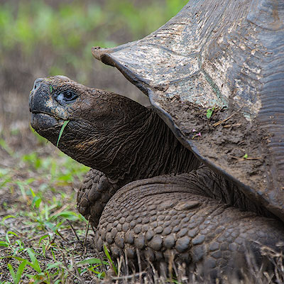
A map of the distribution of Giant Tortoise on each island, as well as illustrations of the different forms of different species, is posted on the wall on one side of the hall. The Giant Tortoise is not only the source of the name of the Galapagos Islands, but also one of the most important species that supports the theory of natural evolution. More about it will be covered later.

After lunch, we put on our rubber boots and went out to the open muddy areas to have a close look of the tortoises. Marco had already told us to keep at least two meters away from the wildlife. The tortoises are huge and this distance was enough to get a good look at them. Besides, the turtles were not afraid of people and often walked slowly past us, seemingly unconcerned with our presence.

Giant Tortoises, Rancho El Manzanillo, Santa Cruz Island
Giant Tortoise

There is a small pond in the middle of the open area, probably from the rainwater gathering. We were in the center of Santa Cruz Island, about 400 meters above sea level. July is the dry season on Santa Cruz Island, but the highland is often engulfed in fog and the air is moist, which allows the vegetation to grow. This drives tortoises to migrate to higher ground. They like to rest in muddy ponds, sometimes with a dozen Giant Tortoises gathered together, and it is said that being covered in mud protects them from mosquito bites. When the rainy season comes, the Giant Tortoises migrate to lower elevations on the island where the food is more nutritious.

Giant Tortoises, Rancho El Manzanillo, Santa Cruz Island
The small pond in Rancho El Manzanillo
Tortoise migration routes on Santa Cruz Island
Giant Tortoises’ seasonal migration routes in Santa Cruz Island (based on Max Planck Institute’s research)

We stayed here for about an hour and could see dozens of Giant Tortoises moving around, including a few huge males. The males were over a meter long and could weigh up to 300 kg; the females were much smaller. June and July is the mating season for Giant Tortoises, and we also witnessed a male chasing a female. It seems that the Giant Tortoises can run pretty fast when they are in a hurry, they can advance about 10 meters a minute.

After leaving Rancho El Manzanillo and driving for another half hour, a small town appeared in front of us. We got off the bus at the harbor, Marco briefly introduce the surrounding area and gave us an hour and a half of free time, then we met at the harbor at 4:30 to board the ship.

Puerto Ayora, Santa Cruz Island
Puerto Ayora

I had thought that Galápagos was just a large national park, but in fact the national park covers about 97% of the area, with the remaining 3% inhabited by humans. The largest town is Puerto Ayora, where we are located, with 12,000 residents. Because Santa Cruz Island is located in the center of the entire archipelago, it is the departure point for most tourists and has the most developed commercial and service sector. The second largest town is Puerto Baquerizo Moreno on San Cristobal Island, that is the capital of the Galapagos Islands, with a population of about 7,000 people.

Puerto Ayora, Santa Cruz Island
Puerto Ayora

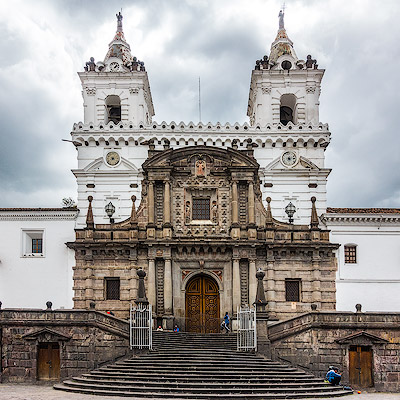
Charles Darwin Street runs along the harbor, lined with restaurants, bars and souvenir stores, and small and large hotels are tucked away in the streets of the city. There are two main ways to visit the Galapagos Islands, one is land-based, where visitors stay in hotels on several of the larger islands at night and visit the sites on the island during the day or take a speedboat to other islands. There are many one-day excursions from Santa Cruz Island to the main islands. The advantage of this way is that it is cheaper and with more choices. In comparison, the cruise option is much more expensive, but it is much more enjoyable as you don’t have to spend hours rushing from island to island and you can visit more distant islands and stop at more attractions.

Puerto Ayora, Santa Cruz Island
Puerto Ayora

We walked all the way down Charles Darwin Street to the small fishing port. Fishermen return from their daily fishing trips and land here, where fresh fish are cleaned on the spot and sent to the restaurants. There are always a few seals and pelicans waiting for the fishermen to throw them something. Sometimes fights break up for the fish or seals can sneak away fish on the ground. This is probably one of the most unique sight in town.

Pelicans at the fish market, Puerto Ayora, Santa Cruz Island
Fishing piers of Puerto Ayora

Fish Market, Puerto Ayora, Santa Cruz Island
Fishing piers of Puerto Ayora

We sat down at a restaurant, had a beer and rested for a while before returning to the port. Puerto Ayora was commercialized, but you can always found a few Marine Iguana on the roadside if we looked down; pelicans and grey herons stood on the mangroves by the sea; baby seals would jump on the dock and interact with the visitors; and a group of rays often swim elegantly in the water under the dock. All these remind us that the unique and mysterious natural world is not far away, waiting for us to explore.

Marine Iguana, Puerto Ayora, Santa Cruz Island
Marine Iguana,Puerto Ayora

Golden Ray, Puerto Ayora, Santa Cruz Island
Rays,Puerto Ayora

Pelican on mangroves, Puerto Ayora, Santa Cruz Island
A Pelican on the mangroves,Puerto Ayora

But human settlement has also had a real impact on the environment. There have been cases of human pets attacking wildlife. One study found that the human food makes it easier for birds to acquire food. After decades of evolution, the pinches living in Puerto Ayora have significantly smaller bills than their counterparts in the forest.

At 4:45, we boarded the Seaman Journey by the zodiac. For the next seven days, we will sail around the western islands of Galápagos.

Seaman Jouney
Seaman Journey
Seaman Jouney
Our room on the Seaman Journey
0 Comments

Quito – Heritage

2018.6.28基多作为厄瓜多尔的首都,名气比起南美洲的其他几个大城市要差不少。不过1978年联合国教科文组织第一次评定世界自然与文化遗产的时候,基多就成为第一个被选入的城市,(同时选入的还有同属厄瓜多尔的加拉帕戈斯群岛)。位于安第斯山脉深处的南美城市,却有着保存最完好的十六、十七世纪西班牙风格的教堂,这后面几百年的历史中,既有伴随着文明冲突的血腥与征服,又有人类文化融合的交流与共生,本身就是十分耐人寻味的事情。

我们计划的太仓促,几个小时的时间只能是走马观花。如果能够在基多再多呆上一天,就可以更仔细地欣赏那些教堂中精美的雕刻,漫步宁静优雅的西班牙庭院,这是这次旅行的一大遗憾。

基多新旧城一般以国家誓言大教堂(Basílica del Voto Nacional)分界,北面是新城和商业区,南面是街道狭窄、教堂林立的老城。从皮钦查火山回到市中心,我们在教堂边下了车,从这里开始游览老城。

Quito street
Students on the street after school

我本以为用几百年的时间修建教堂是十六、七世纪工业革命以前的事情,实际上兴建大教堂的提议始于1883年,经过九年时间的计划设计,于1892年奠基,直到1988年才真正开放。教堂的整体既视感和巴黎圣母院有些相似,西立面的三个入口大门更为相像,但塔楼和后殿以及飞扶壁的设计都颇为不同。最具特色的是,教堂四面墙上的滴水兽雕刻的都是像穿山甲、海龟和蜥蜴这样的本地动物。

Basílica del Voto Nacional

Basílica del Voto Nacional
Gargoyles of Basílica del Voto Nacional

Basílica del Voto Nacional
Statue of Gabriel García Moreno, former President of Ecuador. He was an outstanding politician in the 1860s and 1870s, but was hated by his political opponents for his conservative and iron-fisted rule, and was eventually assassinated after his third election.

Basílica del Voto Nacional
West facade of Basílica del Voto Nacional

我们沿着Venezuela大道一路下坡向南走。想象国内的所谓古城,多半路边早已被各据特色、真古仿古的商家占领,而这里还保留着殖民时代建筑的样子。二层是宽大的窗户或是窄窄的、摆放着鲜花的阳台,一层是一间间朝向大街的小店。多是独门独户,只开一个大门,没有窗户,大概和防盗安全的考虑有关。直到接近独立广场的街区才有比较大的商家。

Venezuela Street, Quito
Look back at Basílica del Voto Nacional from Venezuela street

Venezuela Street, Quito
Venezuela street

Venezuela Street, Quito
Look at El Panecillo and Loma El Panecillo from Venezuela street

Venezuela Street, Quito
Venezuela street

独立广场是基多的中心广场,总统府、市政府和基多大教堂分列在广场四周,不过面积和气象还是比不上秘鲁利马和库斯科的中心广场。和所有拉丁美洲国家一样,城市广场不但是市政和宗教的中心,也是市民聚会休闲的地方。人们喜欢在广场的长椅上闲坐,和朋友或是陌生人聊天,打发时间。

19世纪末,为了纪念厄瓜多尔独立100周年,原本位于广场中心的喷泉被移到广场的一侧,在喷泉所在的位置树立起纪念独立的纪念碑,广场的名称也从殖民时期的“大广场(Plaza Grande)”改名为“独立广场(Plaza de la Independencia)”。一般认为,于1809年8月10日成立的自治政府和发表的宣言标志了厄瓜多尔独立的最初诉求,又被称为“the first cry of independence”(独立的第一声呐喊)。实际上在此之后,厄瓜多尔的独立又经过了多次的反复,所以说起厄瓜多尔真正从西班牙殖民统治下独立的时间,还真没有一个统一的说法。

Plaza de la Independencia
The Independence Monument in Plaza de la Independencia

从独立广场转到García Moreno大街,这条大街从南到北有七座十字架矗立在路边的教堂和建筑前,所以又被称为“七十字架大街”。

Catedral Metropolitana, Plaza de la Independencia
The cross next to the Catedral Metropolitana

圣殿教堂(Iglesia de El Sagrario)就在独立广场到García Moreno的转角处,实际上可以算是基多大教堂的一部分。走入教堂,最让人惊叹的要数金光耀眼的祭坛。教堂继承了西班牙教堂装饰精细繁复的特点,木制祭坛的每一处浮雕花纹,柱身、柱头上的装饰,覆盖了祭坛的每一寸表面,无不精细绝伦。教堂的灯光虽然昏暗,镀金的祭坛却依然灿烂得让人难以侧目。金子对人类果然有一种天然的魔力,让人忽略其它的东西,实际上教堂翡翠色的穹顶也是非常漂亮。

Iglesia de El Sagrario
The alter of Iglesia de El Sagrario

Iglesia de El Sagrario
The arches of Iglesia de El Sagrario

再向前走是耶稣会教堂Church of la Compañía de Jesús),它的街口也有一座十字架。耶稣会教堂始建于1605年,花了160年才建成。教堂的面积不是很大,却是基多最著名的教堂之一。在教堂建造的过程中混合了多种建筑风格,其中以巴洛克风格为主体,这从教堂的正立面就可以看的出来。教堂的大门两侧是螺旋式的所罗门柱(solomonic column),柱顶是极具装饰性的科林斯样式(Corinthian order);上层的柱式有所不同,但花纹同样精美。复杂、精细甚至有些夸张的装饰正是巴洛克建筑的特点。教堂的内部更是全部以金叶覆盖,极尽奢华之事,可惜我们没能够进去参观。

Church of la Compañía de Jesús
The cross next to Church of la Compañía de Jesús

Church of la Compañía de Jesús

Church of la Compañía de Jesús
The entrance of Church of la Compañía de Jesús and Solomonic Columns

从García Moreno大街向右一转,就到了圣弗朗西斯科广场(Plaza de San Francisco)。广场的西侧是圣弗朗西斯科教堂,这是基多最早的天主教堂。靠近教堂的一角是一家历史悠久的酒店,Casa Gangotena,在殖民时期以前曾经是印加的行宫。

Plaza de San Francisco

导游的车停在广场的一侧。我们从国家誓言大教堂走到圣弗朗西斯科广场,可以说是基多旧城的精华,只可惜太过浮光掠影,今后有机会一定多停留几天。

面包山是基多一日游的最后一站。导游的车沿着山路徐徐而上,不一会就到了山顶。面包山上最醒目的是山顶上圣母玛丽亚的雕塑(Virgin of El Panecillo)。雕像建于1976年,有45米高,由7400铝片拼接而成。圣母的形象是手持锁链,拴住脚下踩着一条蛇。这是西方宗教和艺术中常见的圣母玛丽亚的形象,蛇代表邪恶,圣经中表现的意义是圣母借助耶稣的力量可以战胜原罪和魔鬼。比较与众不同的是圣母像身后的翅膀,因为翅膀往往只有在天使的形象中才会出现。雕像的作者西班牙人Agustín de la Herrán Matorras应该是有意致敬著名的“基多的圣母(Virgen de Quito)”雕像。这座高120厘米的木像作于1734年,又被称为“舞者”,形象更加的灵动、栩栩如生。

El Panecillo
Virgin of El Panecillo

面包山(El Panecillo)高约200米,就位于基多老城的旁边,是个俯瞰老城的好地方。而另一侧的山坡上,各色的房屋密密麻麻的铺满山坡,可以看出上民房,大概上穷人住的为多吧。

Loma El Panecillo, El Panecillo
Overlook the old city of Quito from El Panecillo

Loma El Panecillo, El Panecillo
Buildings on the hill slope next to El Panecillo

剩下的自由活动的时间,导游把我们放在手工制品的集市,Mercado Artesanal。不过时间已经是下午两点,我们还没有吃午饭,所以我们决定先去Plaza Foch看看。

从集市走过去不远,大约15分钟的时间。Plaza Foch位于两条大街的十字交叉口,充斥着价格不菲的咖啡厅、酒吧、舞厅和旅游纪念品商店。虽然非常商业化,不是寻访传统本源的地方,但是对于外来的游客来说,有一个熟悉方便的环境也是十分重要,毕竟在旅游中不能总是新奇和挑战。就像我们离开埃及卢卡索、历经艰辛到达希腊的科孚岛、一眼看见山顶的星巴克的那种感觉,是一种无法替代的安全感和慰籍。

Plaza Foch
Plaza Foch

我们在一家叫Mama Clorinda的餐馆坐下来吃了午饭。这是一家主打厄瓜多尔传统美食的餐馆。常常有人把基多和利马两座城市做比较,以美食为标准来看,利马还是要更加多样、更加美味一些。不过下面这个像粽子一样的东西非常好吃。

Tamal Lojano, Mama Clorinda
Tamal Lojano, Made from white corn dough, with chicken all wrapped and steamed in banana leaves.

Seco de Chivo, Mama Clorinda
Seco de Chivo, Lamb cooked slowly in a sauce of onions, garlic, pepper, tomatoes, herbs and spices, served with potatoes, salad, rice and avocado.

吃过午饭,我们走回Mercado Artesanal。这个集市大约只有一个街区大小的面积,里面是一排排密密麻麻的贩卖安第斯山脉风格的纺织品和皮制品的摊位。吸引了很多外国游客在此购物。

Mercado Artesanal
Mercado Artesanal

Mercado Artesanal
Mercado Artesanal

0 Comments

Quito – City

2018.6.28As usual, our trip to Galápagos was not fully confirmed until only days before departure. Up until two weeks before departure, I was torn between Galápagos and Greenland. I even had the connection flights between Greenland and the Faroe Islands all planed out, but in the end it felt like time was running out, and it was much easier to plan the Galápagos plan, mostly because we would stay on the small cruise boat without having to think about the daily itinerary. The week before we left, the cruise boat was finally confirmed, the itinerary was good, and the travel agent gave us a free day trip in Quito.

If you read the online travel forums, Quito is described as an super dangerous city. Someone even said that all taxis in Quito have a Panic Button, and if someone opens the door and jumps in, the passenger can push the button and the camera in the taxi kicks in and starts recording. We didn’t see such devices in a taxi anyway. Quito, like many cities in South America, or most of the less developed countries of the world, is chaotic and noisy, but as long as you don’t go to the unsafe neighborhoods at night, it’s usually far less scary than it’s described online.

Flights from the US to South America always seem to arrive at midnight. We had a connecting flight in Miami, the flight was scheduled to arrive at 10pm, but it was actually more than an hour late. Luckily, we had arranged the hotel pick up in advance. Quito’s international airport is quite far from the city and takes about 50 minutes to reach the hotel. Passing through a valley, we saw city lights ahead, we thought we were not far from Quito. The driver told us it was Tumbaco and was only halfway there.

It was one o’clock in the night when we arrived at the hotel and it took almost ten minutes before anyone heard the doorbell and came out to check on the door. Our hotel is Hotel Casa Q. It is located in the business district of Quito, not quite downtown. The hotel is not large, but well maintained. You can notice that the owner put a lot of thoughts into the design. It was at breakfast time the next day that we were able to see what the surrounding streets looked like.

Hotel Casa Q
Breakfast in Hotel Casa Q

Quito street near Hotel Casa Q
Quito city looking from the hotel

The booked city tour was supposed to start at 9am and the guide arrived at almost 10am. This is common in South America and part of the local culture. The first stop on the day trip is a cable car ride up Pichincha Volcano. Quito is located in a valley at the eastern foot of the Pichincha volcano. At 10 o’clock, the streets are very crowded with traffic. The main road is mostly two-way, four-lane and looks modern, and but the small streets are still a bit messy.

Quito Street
Quito’s local street

Quito street
Quito’s local street

The gondola to Mount Pichincha is called TelefériQo. the station at the foot of the mountain is on the edge of Quito, the facilities were still new and there were not many tourists. Probably the maximum capacity of one car is six people, there are six circles on the ground where the car was boarded, and each one of us stood in the circle waiting for the car.

The TeleferiQo to the top of Cruz Loma
Boarding the gondola to Pichincha

The cable car took about 20 minutes to get from the foot of the mountain, which is 10,226 feet above sea level, and the drop-off point is 12,943 feet. The vegetation at this height is mostly shrubs with some low trees. Further up, the woods fade away and the grass gets shorter and sparser. At the top of the mountain is the Ruku volcano, which is 15,696 feet above sea level. The most recent eruption was in 1999, falling several inches thick of ash into the city of Quito.

Cruz Loma
Pichincha volcano

Rucu Pichincha climbing route
Climbing route to Ruku Pichincha

Cruz Loma
Visitors to Pichincha volcano

We walked up to an elevation of about 4,000 meters. This is the highest elevation we’ve ever been to. Indeed I had to breath heavier when I walked faster. There are plenty of places in between to stop and overlook the city. July is the dry season in Ecuador. According to the guide, it should be sunny all day, but the clouds were low and the city of Quito was hidden from time to time in the clouds. It’s on the cable car when we ware under the clouds, we were able to get a panoramic view of Quito.

The TeleferiQo to the top of Cruz Loma
Overlook Quito from TelefériQo

The following day trip was a city-tour to the old town. I will cover it in another blog.

We took the taxi from the marketplace to the hotel in the afternoon. We had book the dinner at Zazu. It’s only one block away from the old, there were plenty of time left to explore the surrounding places. The hotel attendant said there’s a Food Garden not far from where we were. Just make a turn from the hotel to the street where Zazu is, we found the road lined with restaurants from the low-end street food to the high-end establishments. We walked into o restaurant called Swing at the corner. Listening to the familiar disco dance music, there’s suddenly a feeling of lost in time.

Overlook mountains at La Pradera
Mount Pichincha in sunset

Zerdo
Zerdo Restaurant

La Pradera Food Garden is just two blocks from us at the intersection of de la Republica Avenue. It looks bland from the outside, but it’s getting more interesting when you walk in. The modest area is home to dozens of open space eateries, each with its own distinctive style, with relaxing atmosphere. Such a place to put in America would also be a gathering place for trendy young people. It was 6pm and there weren’t many people. Maybe it’s because it’s not the weekend, or maybe such spending is still a bit high for locals.

La Pradera Food Garden

La Pradera Food Garden

Dinner reservations at Zazu are at 7pm. From the design to the plating, Zazu is one of the more upscale restaurants with moderate prices by American standards. We ordered the chef’s tasting menu. It look certainly beautiful, but the taste were not as exciting.

Restaurante Zazu
Tasting menu in Zazu

Restaurante Zazu
Tasting menu in Zazu

0 Comments

Jackson Hole – Fireside Resort

2018.2.18因为没有订到今晚Hotel Terra的房间,从狗拉雪橇回来,我们就取了行李,打车去往今晚的住处,Fireside Resort。Fireside Resort位于Teton Village和Jackson镇之间,从照片上看像是木屋旅馆的感觉。虽然看起来颇有情调,但我们也没抱太大的希望。毕竟这几天住的已经很舒服,一个晚上怎么都可以过的去。

Fireside Resort就在主路的边上,Uber一直把我们拉到院子尽头。注册的地方与一般旅馆不同,就是一间木屋,设施非常简单。我们被安排到离大路不远的入口的一头。进了门,虽然房间不大,但是分内外两间,温暖明亮,方便舒适。大多数木屋都住了人,温暖的灯光从一间间木屋传出来,映射在傍晚泛着蓝色色调的雪地上,别有一番浪漫温馨的气氛。我趁吃饭前的一点时间,出去给木屋的照了几张相。

Fireside Resort, Wilson

离旅馆不远就有一家叫Calico的餐馆,评价还不错,走五分钟就能到。虽然说是意大利菜式的餐馆,但餐馆的设计是典型美国西部的风格。自然宽敞、毫不做作,餐桌也是我喜欢的宽大的木制桌子。这里适合家庭聚会,人自然不少,但并不太吵。论菜的质量,也是我们在Jackson Hole吃的最可口的一次。

Calico Restaurant and Bar, Wilson

Calico Restaurant and Bar, Jackson Hole
Calico Restaurant and Bar, Wilson

Calico Restaurant and Bar, Jackson Hole
Calico Restaurant and Bar, Wilson

第二天一早起来,窗外一片白茫茫的感觉。前几天的风雪大多下在山上,落到山谷里的并没有积起来。打开门一看,一片银装素裹,屋外的雪大概积了半尺多厚,应该是下了一晚上的样子。

Fireside Resort, Wilson
Fireside木屋外的积雪

更妙的是,晚上下了雪,到了早晨雪就停了。虽然是阴天,但天光还有一些亮起来的意思。院子里落光了树叶的灌木和乔木,粗粗细细的树干和枝条上,每一根都挂着白亮亮的积雪,一尘不染,对比鲜明,像极了一副黑白写意的山水。

Fireside Resort, Wilson

Fireside Resort, Wilson

Fireside Resort, Wilson

而在这一派黑白世界中,cottonwood黄色枝条就更显得亮眼。对于住在加州的我,这样的雪景实在是难得的机会。趁出发前,我在院子的周围有拍了不少照片。

Fireside Resort, Wilson

Fireside Resort, Wilson

到了出发的时候,早晨颇为明亮的天色变得阴沉起来。路过Jackson镇的时候,路上没有什么行人,更显得萧瑟与困顿。其实这倒是很好的摄影构思和后期处理的题材。

Jackson Hole in snow

Jackson Hole in snow

Jackson Hole in snow

Jackson Hole in snow

到了机场,停在跑道边的车辆器材都被昨夜的大雪覆盖。扫雪车在跑道上来回来去地清理着积雪。飞机起飞的时候,从舷窗望出去,大提顿山脉巍峨的山峰隐没在乌云里,黝黑的snake river蜿蜒在被白雪覆盖的山谷之中。Jackson Hole留给我们的最后印象仍然是她的壮丽威严。

Leaving Jackson Hole

因为我们不滑雪,冬天的出行往往是往暖和的地方去。这次Jackson Hole之旅既让我们体会了冬季的严酷和萧然,又有时刻透出的温暖和浪漫,确是一次难得的旅行体验。

0 Comments

Jackson Hole – Dog Sled

2018.2.17今天的安排是这一行的高潮 – 我们要去参加狗拉雪橇的活动。狗拉雪橇的活动一般要事先预定,而且有提前7天取消的限制。有可能是因为天气原因,我们到旅馆的时候正好有人取消,我们才能挤进来,算是是非常幸运。

我们订的是半天的活动,近中午时有车来接。先是到Jackson镇的旅馆接上另外三对夫妇,然后一路向北,到Moran再往西,大约开了一个小时多一点儿,才到了位于Togwotee山脉的活动地点。这里是北美大陆的水域分界线,所以这里的狗拉雪橇活动叫做“Continental Divide Dog Sledding”。

img_20180217_120412
Jackson镇旅馆门口的木雕

dsc00172
沿途大提顿山脉的山峰

进山越远,路上的积雪越深。我们在Togwotee Mountain Lodge下了车。木屋的房顶上都积了近一米厚的雪,地上的积雪更是高过了窗户。一片北国景象。

Togwotee Mountain Lodge

Togwotee Mountain Lodge
Togwotee Mountain Lodge背后的木屋

我们在这里休息吃午餐,下午的狗拉雪橇活动也从这里出发。木屋设备齐全,前面是酒吧和商店,后面是餐厅,楼上是旅馆。我们在Jackson附近其实没吃到什么好东西,没想到在这个冰天雪地远离市镇的木屋午餐质量却相当不错。汉堡的面包暄软,牛肉做的也是恰到好处、味道十足。

img_20180217_135313
Togwotee Mountain Lodge的午餐

Togwotee木屋是很多冬季活动的出发点。木屋的后面停着几辆机动雪橇。在木屋的后面已经有一队精神抖擞、健康漂亮的雪橇犬准备整装待发。

Togwotee Mountain Lodge
Togwotee Mountain Lodge旁的机动雪橇

Togwotee Mountain Lodge
Togwotee Mountain Lodge一队准备出发的雪橇犬

吃过午饭,绕过木屋的后面一排低矮的小屋,我们的雪橇将从这里出发。几十只雪橇犬站在雪地里,互相间隔大概10米左右的距离。每只雪橇犬都栓着锁链,旁边只有一个塑料桶或是小木箱子,让它们在睡觉的时候能够躲避一下风雪。初看起来实在有些可怜,不过这也与雪橇犬的性格有关。

北美的雪橇犬多为阿拉斯加哈士奇或是爱基斯摩犬,它们忠诚度高、耐力好,同时又好动、怕孤独。因为生活在北极寒冷地区,自古以来就是为了拉雪橇的目的来选种训练,雪橇犬与宠物狗相比有更多的独立和野性。在人类看来拉雪橇是一件繁重甚至悲惨的事情,对雪橇犬来说却是它们天生的本能、求之不得。见到我们到来,一只只雪橇犬都兴奋起来,跃跃欲试地跳着叫着,好像希望自己被选到。

Continental Divide Dogsledding, Togwotee Mountain
向导在为我们的雪橇挑选雪橇犬

Continental Divide Dogsledding, Togwotee Mountain
两队雪橇犬准备出发

每一只雪橇都由七对雪橇犬牵引。为我们驾驶雪橇的是一位女向导。她告诉我们选狗有很多讲究。前面带头的雪橇犬要挑选有经验、听指挥的狗,多为母犬;最后面靠近雪橇的狗承重最多,要挑选年轻健壮的雪橇犬;位于中间的狗要求低些,可以选没有经验的狗来训练。

狗选好了,我们坐进雪橇。雪橇犬们早已迫不及待,向导一声令下,它们就冲了出去。启动一瞬间的刺激只可意会不可言传,真的便如离弦之箭,冲入茫茫雪原。

Continental Divide Dogsledding, Togwotee Mountain
Continental Divide Dog Sled

北美接近北极的地区多为丛林地带,雪橇犬的安排都是排成一队。北欧的极地是开阔的平原,所以那里雪橇犬是扇形排布,便于操控。

近距离观察雪橇犬的跑动,能发现很多有趣的事情。最让人惊奇的是,雪橇犬居然可以在跑动中间小便,只要翘起两只后腿,只用前腿奔跑,丝毫不影响速度。

拉着三个成年人奔跑,实在不是一件轻松的事情。因为狗的身上没有汗腺,身上的热量只能通过张嘴吐舌来散去,所以雪橇犬边跑边会探头去吃道边的雪,来给自己降温。跑的累了,有些狗也会偷懒,找省力的姿势跑出队。到这个时候,向导就会叫领头的狗停下来,让雪橇犬们休息几分钟。

Continental Divide Dogsledding, Togwotee Mountain
中途休息,Continental Divide Dog Sled

Continental Divide Dogsledding, Togwotee Mountain
中途休息,Continental Divide Dog Sled

在Togwotee的狗拉雪橇的活动,路程有十几公里,要跑四五十分钟的时间。中间跨雪原、穿林海,不仅能体会雪中飞驰的刺激,一路的风景也是绝佳。向导说在Jackson附近还有一两处狗拉雪橇的活动,都是混合雪橇和其它项目,真正在雪橇上的时间短、路程也不长,远远不如这里过瘾。

回到出发地点,向导端来混合着血水和牛肉块的食盘,这是对雪橇犬们一路辛苦的奖励。喂完我们这一队雪橇犬,向导又把我们带到几只刚刚出生只有几周的小狗窝前。小狗们温顺可爱,一抱起来就是又亲又昵,一点也怕人。

Continental Divide Dogsledding, Togwotee Mountain
返回驻地,Continental Divide Dog Sled

Continental Divide Dogsledding, Togwotee Mountain
雪橇犬们的奖励,Continental Divide Dog Sled

到了下午,雪下得更大。回到Teton Village,因为我们最后一天没有订到Hotel Terra的房间,晚上我们会换一个旅馆,明天启程返回。

Togwotee Mountain Lodge
风雪中的Togwotee Mountain Lodge

0 Comments

Jackson Hole – Snowshoe Excursion

2018.2.16第三天安排了snowshoeing的活动,下午才开始。上午的时间准备去山顶看看。

从滑雪村出发,有多条索道通往不同的雪道。与一般滑雪场不同的是,大提顿山脉冬天适合滑雪,夏天又有很多徒步的小路。这些索道夏天的时候同样可以把游人送到各处,从山上出发开始健行。我们要坐的索道是Bridger Candola是封闭的缆车,索道的尽头不但是雪道起点,还有一家不错的餐馆,Piste Mountain Bistro。

Overlook the teton village from a cabin of the Bridge Gondola
上山的Candola索道

Overlook the valley at the top of the Bridge Bondola
从雪道出发处俯瞰大提顿山谷

索道尽头、餐馆的外面有一篇空地,天气好的时候可遥望远山,无论冬夏都是视野开阔、大气磅礴的观景点。可惜天公不作美,这几天都是风雪天气,云层几乎压到我们头顶,不时还下起雨雪。山脚下的山谷已经是看不太清,更不用说对面山峦了。气温自然也是极冷,在外面站一会儿就感觉寒气入骨。

Top of the Bridge Bondola

滑雪的人依然不少。雪道出发点海拔2700米,山脚下不到2000米,七八百米的落差几分钟就下去了。我们在餐馆吃了午餐,坐缆车而下。

Top of the Bridge Bondola

Top of the Bridge Bondola

下午领导自己去Jackson逛,我去参加snowshoeing的活动。一般户外活动的向导多是男性,这次是一个女生,同行的还有一对年轻的美国夫妇。我们开车向北,进入大提顿国家公园的范围。到了停车地点,导游发了雪鞋和拐杖。为了防止体力不支,还让我们各自拿了一些补充热量的能量bar。

雪鞋和滑雪撬不同的地方除了宽一些和短很多以外,一个重要的区别是只有脚尖固定在鞋上,脚跟和鞋不固定,这样脚抬起来的时候,鞋子不会完全离开地面,便于行走。

我们一开始就向着一片空地走过去。茫茫原野和树林,很难找到什么参照物。走的远了,还真不容易定位。导游当然对周围的地形很熟悉,还是偶尔需要看看GPS的位置。我们先是穿过一片旷野,然后多是在树林里穿行。导游征求了大家意见,觉得体力没有问题,又走了一些平缓的山坡。

Snowshoe Excursion

Snowshoe Excursion

和前一天看野生动物的时候差不多,今天更是一只活物也没有见到。但是看起来了然无趣的雪原,在导游眼里却到处都是生命的痕迹。一路上导游给我们不停地指识,有的时候是鸟类和鹿的脚印,更多的是熊留在树上的爪印,或者是在树上蹭痒标示体味的印记。在野地里行走,识别追寻动物的行踪是一项野外生存必不可少的技能。

img_20180216_143738
导游在检查熊在树干上留下的痕迹

不过这一行的最大发现却要归功于同行的美国夫妇。人的眼睛不经过训练,树林里面即使离得很近的东西也不容易看见,不过他们却在离我们十米左右的树下看到一只Elk的尸体。内脏和肌肉已经被吃的干干净净,在这严酷的冬季,任何一点能量都不会被大自然所浪费。一头成年的Elk只剩下了一副骨架和鹿角。这个发现让导游都很兴奋,赶紧拍了照片转发给她的同事。

Snowshoe Excursion

除了动物的行踪,雪地里还偶尔能看到当年定居者留下的遗迹。我们走了大约三个小时才返回出发点,我还有点儿意犹未尽的感觉,当然能看到些动物就更好了。

Snowshoe Excursion

Snowshoe Excursion

晚上和领导汇合,准备去Thai Teton Village吃晚餐。餐馆不在滑雪村里面,走出去大概也就是两三百米的距离。到了晚上风大了起来,大风卷着雪花敲打在人的身上;向前看去,雪花在路灯下漫天飞舞,让人几乎鼓不起勇气走入风雪之中。到了餐馆,里面人很多,我们只好在四处漏风的前台等候,围着火炉,喝着啤酒,举杯向终于轮到的食客庆祝。幸运的是,这家的泰餐很有水准。不过吃过饭还要走回旅馆去,什么叫“风雪夜归人”,这次真正让我们体会到了!

0 Comments

Jackson Hole – Wildlife Tour

2018.2.15第二天一早是看野生动物的项目。吃过早饭,导游准时来接。车是一辆大SUV,游客只有我们两个。我们先是一路开到Jackson,穿过市区,开上西边的National Elk Rufege Road。Jackson Hole指的是大提顿山脉中的山谷,Jackson镇就位于山谷的最南端。镇边山谷中开阔的草甸上,经常有成群的Elk来觅食,所以被划做保护区。(Elk的中文翻译不是很清楚,而且欧洲和北美对Elk和Moose的叫法也不同,就况且叫麋鹿吧。)

Wildlife Tour
1912年政府买下这片草场作为麋鹿保护区,Miller Cabin是当时管理保护区的办公地点

Wildlife Tour
冻结湖面上成群的天鹅

Rams on the hill, Wildlife Tour
山顶上时隐时现的角羊(Ram)

作为导游的基本素质就是要健谈,我们的导游也不例外。他不但对所见到的动植物如数家珍,对当地的文化政治也颇有见地。我们在National Elk Rufege Road上并没有开太远,就掉头回到市内,在Jackson的访客中心稍作休整。雪渐渐大了起来,早上九点,街上没有什么行人。停车场里零星停着的车辆上覆盖了一层厚厚的新雪,一派小镇冬季的萧瑟景象。

Jackson
Jackson镇访客中心(Jackson Home Ranch Welcome Center)边的停车场

我们沿着高速191一路向北,雪下个不停,整个世界都笼罩在暗淡的薄雾中。路过麋鹿保护区,远远可以看到一群群的麋鹿或坐或立,却因为风雪的缘故只是隐隐约约,几乎与背景和雪幕混为一色。走不远又见到在湖中游弋的天鹅,似乎并不在意冰冷的湖水和满天的飞雪。这里的冬天严酷、冷漠,都所有的生命都是巨大的挑战。

Elks in the blizzard, Wildlife Tour
风雪中隐隐约约的麋鹿群

Mooses in the woods, Wildlife Tour
卧在林间的驼鹿(Moose)。驼鹿毛色黝黑,体型巨大,成年驼鹿体重可达500公斤。若是狭路相逢,人类还是退避三舍为好。

山谷里地形平坦,河流虽然都已结冰,但却有温泉注入的小溪和湖泊点缀,其中有小鱼和野鸭在这难得的温暖中生存。想想也不奇怪,黄石地区作为一个巨大的火山口,地热资源一定是很丰富的。

Wildlife Tour
因地热而不冻结的小溪

Jackson Hole山谷东侧的天气一般要比雪场一侧的天气要好。越向北走,雪渐渐停了,太阳也时不时从乌云后露出头来。若是拨云见日,远山轮廓分明,真有大雪初霁,生机盎然之感;但若乌云蔽日,则天地一色,又让人不禁想起“千山鸟飞绝,万径人踪灭”的诗句。

Wildlife Tour
阳光下Jackson Hole雪后的山谷

Wildlife Tour
阴云密布的Jackson Hole山谷

一路上看到的动物其实不多,也许是天气的原因,动物也不愿意出来吧。一路上可以见到不少人类定居、储存粮食的遗迹,但是大提顿的冬天漫长冷酷,几乎没有什么农作物能够生长,如果没有现代工业的帮助,人类即使能够短暂定居,但是长久以往、加上时过境迁,多数还是被放弃了。

A fox in the field, Wildlife Tour
荒野中孤狼

A mule deer, Wildlife Tour
在荒废的定居点出没的鹿群

An abondand village, Wildlife Tour
被遗弃的定居点,也许夏天还有人在此活动

Cottonwood in golden color, Near Jackson
Cottonwood的枝条呈金黄色,在雪地中十分显眼。

我们回到酒店的时间正是中午,在外面转了大约四个小时的时间。就算碰到牦牛是可遇而不可求,其它的动物看到的也不多。不过在看野生动物本来就是碰运气的事情,就当是体验一下大提顿野外的冬天吧。

吃过午饭,我们下午准备去Jackson镇里逛逛。从滑雪场每隔20分钟就有一躺公交车出发去Jackson,就在滑雪场的钟楼前的停产场上车。主要的乘客都是来滑雪的当地人,加上像我们这样进城的游客。

Teton Village, WY
滑雪场的钟楼

公交车大概半个多小时就开到Jackson镇,我们在镇中心的广场下了车。镇中心的广场有点儿拉丁美洲的风格,中间是方方正正的绿地,四周是一圈的餐馆、商店和画廊,向四周发散。不远处的山上就有个小滑雪场。住在镇子上,所有的活动都不会被落下。

Jackson, WY
Million Dollar Cowboy Bar

Jackson, WY
Shops in Jackson

dsc00128
Jackson

Jackson的标志是用鹿角搭成的拱门,在中心广场的四个角各有一个,每个拱门都有1000副左右的鹿角。鹿角是一体的骨质结构、庞大坚硬,公鹿每年都要换上一副,春天生长到冬天或是初春脱落,唯一的目的就是在生殖季节与其它公鹿争夺配偶。鹿角时间久了还是会腐烂,Jackson镇于1953年竖立起第一个鹿角拱门,现在的拱门是2007到2013年期间重建的。

Jackson, WY
Jackson Town Square

Gather Restaurant, Jackson, WY

0 Comments

Jackson Hole – Arrival

2018.2.14我们的旅行计划一直遵循着一种候鸟式的安排,夏天在北半球,冬天去一个温暖的地方。偶然间在网上看到一篇”Ski Resorts for Non-Skiers”的文章,心里就想着为何不换个口味,冬天去一个冰天雪地的地方旅行。计划行程的时候,我们反复在黄石公园附近Jackson Hole的Hotel Terra和位于科罗拉多州Telluride的Madeline Hotel之间犹豫。最终因为从旧金山到Jackson Hole有直达航班、行程方便,决定了去Jackson Hole。

飞机快要降落的时候,已经看到白雪覆盖的大地、河谷和大提顿国家公园雄伟的山脉,虽然云层笼罩,但看起来天气不错。

Overlook Teton Range, Jackson Hole

一下飞机,一股寒风吹来,我们都赶紧竖起衣领。远处群山巍峨,白雪皑皑,视野开阔,一别城市的拥挤局促。出了机场门,叫了Uber,来的居然是一辆Ram Truck。Jackson Hole的Uber都是这种大型卡车或是吉普,为的是方便承载客人和他们的滑雪装备。

Leaving Jackson Hole Airport
Leaving Jackson Hole Aireport

从机场到Hotel Terra所在的Teton Village开车要40分钟,走一个U字形,U字的底端是Jackson镇。Teton Village是典型的滑雪场的旅馆群,Hotel Terra是这里面比较大的一个。出门就是缆车,从雪场可以直接滑到旅馆门口,旅馆里有不错的餐馆,二层和顶楼还有热温泉。泡在冒着蒸汽的热水里,看着飘落的雪花,仰望满天星斗,真是一大享受。

Hotel Terra, Teton Village

Hotel Terra, Teton Village

Hotel Terra, Teton Village

我后来才明白,其实各种雪上活动和住哪个旅馆没什么关系,只要订好了项目,到了时间向导就会去旅馆接游客。不滑雪的话,住在Jackson镇上也是个不错的选择,旅馆价格应该会便宜不少,当然滑雪场的氛围就体会不到了。而且像我们这样没有事先预订,热门的项目多半会订不到。我们第二天参加的看野生动物的项目,虽然才是二月份,已经有游客给导游打电话预定夏天的时间了。大的旅馆有专人帮助客人,和导游关系也好,这时候就显出了优势。我们比较幸运,到了晚上,三天里每天参加的项目都有了着落。

天黑了从旅馆里走出来,才发现下起了大雪。Hotel Terra门外就是一块滑冰场,地面上已经积了一层厚厚的新雪。站在冰场边,看着翩翩而下的雪花,冰场上有低声细语的情侣缓缓而行,又夹杂着小朋友戏雪的欢笑声,可见如此浪漫的场景并不是只在电视剧里出现。

Teton Village
Teton Village

Teton Village, WY
Teton Village

Teton Village
风雪夜归人,Teton Village

我们在滑雪村里走了一圈。远处有更高级的酒店,离雪道更近。我们看了一圈没有找到合适的餐馆,又回到旅馆附近的Spur Restaurant。这里评分很高,人声鼎沸。一众好友滑完雪在这里喝一杯,是个不错的选择。

Teton Village
Teton Village

Alpenhof Bistro & Dietrich's, Teton Village
Alpenhof Bistro & Dietrich’s, Teton Village

Outside of Spur Restaurant & Bar, Teton Village

0 Comments

Copenhagen – Day Trip – Roskilde

2017.10.21罗斯基勒Roskilde)的历史比哥本哈根更久,自维京时代起就是丹麦最重要的城市和宗教中心,从11世纪到15世纪中叶,这里还是丹麦王国的首都。罗斯基勒位于哥本哈根以西30公里,乘火车30分钟就可以到达,是一个理想的一日游的地点。

一出火车站就看到小广场上屹立的三个巨大的陶罐,这是丹麦抽象派雕塑家Peter Brandes所做,于1998年罗斯基勒建城1000年纪念时放置在此处。再向前走就是横贯罗斯基勒市中心的商业街。我们在这里吃了一点东西、稍事休息,决定先打车去维京海盗船博物馆。

Roskilde
罗斯基勒火车站广场上的罐子雕塑(Roskilde Jars)

Roskilde
罗斯基勒市中心的商业街

罗斯基勒位于罗斯基勒峡湾(Roskilde Fjord)的最南部。从地图上看,罗斯基勒峡湾的形状非常特殊,一开始是一个90度的拐弯,然后是一段狭长的海道,最后海道阔宽,下端呈近乎方形的海域。整个峡湾就像一个口袋,罗斯基勒就位于这个口袋的最底部,易守难攻;城市的位置又是处于Zealand的中心,难怪会成为早期丹麦最重要的城市和交易港口。

Roskilde Cathedral, Roskilde, Region Sjælland, Denmark

1962年,就在这段狭长海道的中间接近Skuldelev的地方,考古人员挖掘打捞出5艘维京时代的海盗船。沉船上压有石块,可见是有意沉到水底,用来阻挡航道,便于防守外敌的进攻。沉船的时间大约是公元1070年左右,那时候的北欧虽然还没有现代意义上的国家,但是斯堪的纳维亚半岛犬牙交错的海岸线却让当地的维京人发展起领先欧洲的造船技术。维京人不仅仅是海盗,同时也和周边的国家进行贸易。他们先是占领了冰岛和格陵兰岛,以此为跳板,维京人很可能是第一个涉足美洲新大陆的欧洲人。近代的研究显示,他们的足迹甚至远达地中海和黑海,到达东罗马帝国控制的区域。

Viking Ship Museum, Roskilde
罗斯基勒的海盗船博物馆

Viking Ship Museum, Roskilde
罗斯基勒海盗船博物馆里展示的沉船

罗斯基勒的海盗船博物馆面向海湾而建,里面摆放着打捞出的5艘海盗船,其中既有体型较宽的货船,也有船体细长的战船。除了对海盗船的介绍,博物馆里还详细介绍的维京部落的兴衰历史。天空仍然十分阴霾,但若是个春和景明的天气,必不能体会维京人在苦寒的气候中、恶劣的海洋环境里生存扩张的坚韧和勇气。博物馆外还有一个小型的造船工地,用当时的方法制造维京人的海盗船,也让游人亲身体会当年造船所使用的工具和技术。

Viking Ship Museum, Roskilde
罗斯基勒的海盗船博物馆外的造船工地

Viking Ship Museum, Roskilde
连接博物馆和造船工地的小桥

Café Knarr, Roskilde
Café Knarr,罗斯基勒

在博物馆边的Café Knarr吃完午饭已经快4点了。从海边向城内走,一路上都是这几天到处所见的郁郁葱葱。走到罗斯基勒的大教堂的时候才发现,教堂4点种关门,教堂周围的广场上冷冷清清,已经一个人也没有了。

Byparken city park, Roskilde
罗斯基勒的城市公园

House near Roskilde Cathedral, Rosklide
罗斯基勒大教堂边的民居

维京后期,基督教开始传入北欧。作为丹麦的宗教中心,在12到13世纪,罗斯基勒建立起第一座砖结构的大教堂,此后共有39位皇室成员安葬于此,可见罗斯基勒在丹麦王国的地位。可惜我们没有事先计划好,错过了参观的机会,只好围着教堂转了一圈。

Roskilde Cathedral, Rosklide
罗斯基勒大教堂(Roskilde Cathedral

Roskilde Cathedral, Rosklide
罗斯基勒大教堂前广场

Roskilde Cathedral, Rosklide
罗斯基勒大教堂侧面的红叶

离开教堂,又回到罗斯基勒市中心的商业街。这里是一片开阔的广场,一侧是罗斯基勒的旧市政厅。

The Cathedral Museum, Roskilde
罗斯基勒的旧市政厅(Byens hus)

The Old City Hall (Byens hus) of Roskilde
罗斯基勒的旧市政厅(Byens hus)

罗斯基勒的火车站还保持着小车站的风格,一条地下通道连接着一个个站台。站台都是开放式的,一道道铁轨汇聚于此,颇有怀旧的味道。

Greyfriars Cemetery (Gråbrødre Kirkegård), Rosklide
罗斯基勒火车站旁的一处墓地,Greyfriars Cemetery

Railway station, Roskilde
罗斯基勒火车站

0 Comments