Peru – Preparation

Except Antarctic, South America is the last continent we have not stepped on. After evaluating A (Argentina), B (Brazil), C (Chile) and Peru, we picked Peru at last, not only because of its world-famous landmarks, such as Machu Picchu and Nazca Lines, but also for its rich traditions in culture and food and geographic diversity – the country has sea coast, desert, highland and Amazon rain forest within its 500-square-mile area.

Because we’re going to visit Amazon jungles and the highland at 12,000 feet high, we brought pills for Malaria and high altitude sickness. We also took a Hepatitis A shot, so we would have no worry about taking local food like Ceviche.

0 Comments

Yucatán, Mexico – People

Mexican people share the happy spirit in their hearts no matter where they live or how much they earn. Here in California, it seems the Mexican people are having party all the time. This is same in their native country. Compared to Americans or Chinese, they place much higher value on their society, family and friends. At the city, you can often see large families gathering at the park, friends hanging out in cafés. The life is simpler and the pace is slower. People don’t seem to worry at all – they live in the present. They are also very friendly to visitors. They like to start the conversation with you at the gas station, in the restaurants. Unlike in Egypt, where the talk often leads to the sales pitch; here, it is the real hospitality.

Valladolid, Mexico
Valladolid, Mexico
Chichén Itzá, Mexico
Mérida, Mexico
Mérida, Mexico
Mérida, Mexico
Mérida, Mexico
Mérida, Mexico
Mérida, Mexico
0 Comments

Yucatán, Mexico – Nature

Yucatán Peninsula has no river and only a few lakes, but it has a unique underground water system that provided major source of quality water for ancient Mayans. The underground water is accessed through the cenote. The most famous one is the sacred cenote in Chichén Itzá, but a lot of cenotes don’t necessarily have a open water pool. They are sheltered by rocks and caves. Cenotes can be found in much of the peninsula and some theme parks offer activities to visitors to walk and swim through the underground rivers and cenotes.

After we decided not to see Chichén Itzá in the late afternoon, we visited Cenote Dzitnup near Valladolid. Walked down a flight of steep stone steps, this cenote is at the bottom of a cavern. Tree roots grow through rocks and hang above the water. Cenote water is often very clear and flow super slowly. Many people like to swim in the water.

Cenote Dzitnup
Cenote Dzitnup

We saved the best for the last and went to see flamingos at Celestún Wildlife Refuge on our last day of the trip. It’s at 60 miles west of Mérida. After we were out of city, the road became 2-lane highway and we could only see jungles along the road. We passed small cities and villages every once a while. Most of the cities share the same colonial style as Valladolid and Mérida. Unlike the bigger cities, many people, especial woman, were in their traditional costume.

It took us almost 2 hours to get to Celestún. Right after passing the bridge over the lagoon, boats were waiting for visitors by the shore. We shared the boat with another Chinese couple. From the bag that the man carried, I knew that both of us came here for the same reason, to photograph birds. Once the boat started moving, we took the camera out of the bag, switched to the long-zoom lens. The sound of ‘click’ never stopped throughout the ride.

The lagoon is 30-mile long but only half-a-mile wide. The water is feed by 80 cenotes underground. It’s very shallow and ideal for flamingos and other waterfowl species. After about 20-minute ride, we got to the north end of the lagoon. The flock contains thousands of flamingos here. Looking from afar, they made a pink line along the horizon. To protect their habitat, boat is not allowed to get too close to the birds. Luckily, it was barely in the reach of my 200mm lens. Other stops after watching flamingos were less interesting, but we could see other birds, such as pelicans and egrets, in much closer distance.

Celestún Wildlife Refuge
0 Comments

Yucatán, Mexico – City

At Cancún, the hotel we stayed in was at the hotel zone. One night, we went out and tried to find the downtown of Cancún but got lost after entering the city. No one spoke English out of the tourist area. Probably in Spanish ‘downtown’ has a different meaning. We eventually gave up and went back to hotel. We walked to the La Isla Shopping Mall nearby. This is an outdoor mall totally in American style. The best design is that it has a man-made canal winding through the area. It’s a very pleasant night.

Playa del Carmen is a lively town 40 miles south to Cancún. We stopped by for about an hour on our way to Tulum. Although the size is still small, tourism has made this once quite beach town much more comercialized today. The main street is lined with small shops and restaurants. Chain stores, such as Starbucks and McDonald’s, can be easily found. Only a few streets away, the sea coast offers high-quality beaches and unbeatable views of blue water. It was one of most crowded beach I had ever seen.

Playa del Carmen, Square

Playa del Carmen, Hat Store

Playa del Carmen, Street

Playa del Carmen


Valladolid is a small colonial city halfway between Cancún and Mérida. We stopped by for one night as we visited the close-by ruin Chichén Itzá. Similar to other colonial cities in Yucatán Peninsula, Valladolid has a chessboard-like street grid. At the city center, it’s a plaza with a park square in the middle, surrounded by stores and a cathedral, La Parroquia de San Servacio. We walked around the main square. The late afternoon sun casted lovely colors on the buildings. The hotel we stayed was Ecotel Quinta Regia. Considering the size of the city, the hotel is quite large. The building are painted with vivid colors and the environment was quiet and nice. It has its own restaurant, a pool and even raises chickens and geese at one corner of the hotel.

Valladolid, La Parroquia de San Servacio
Plaza Mayor and La Parroquia de San Servacio

Valladolid, La Parroquia de San Servacio
Inside La Parroquia de San Servacio

Valladolid, Central Plaza
Plaza Mayor

Valladolid, Streets
Valladolid central district

Valladolid, Ecotel Quinta Regia
Ecotel Quinta Regia


Mérida is the capital city of Yucatán and has been the dominant city of the peninsula since it was founded in 1542 on the ruins of a major Maya settlement. The city is also built on a grid system. A highway runs around the city, which extends about 60 blocks to each direction. In the center, it is Plaza Mayor that features the majestic Catedral de San Ildefonso, the city hall and shops and restaurants. Central Mérida is active and busy, but it also suffers from the problem of other big cities – traffic and pollution. In the day time, tourist buses and cars jammed roads around the central area, mainly because the streets are not any wider than other places.

We tried to booked Mexican style hotels before the trip. They are normally small but very elegant, and often rated at the very top on the travel websites. Unfortunately, there were all booked during the holiday season, so we eventually picked Hyatt Regency Hotel. It is located about 40 blocks north from the center, at the most fashionable district of the city. The streets are lined with luxury mansions of 100-year history; poles and arches were decorated with lights for the holidays. We had a walk along the tree-lined Paseo de Montejo boulevard at the last night we stayed. About 30 pieces of Leonora Carrington‘s sculpture works were displayed on the sidewalk. The area was quite and clean. It made a distinct contrast to the noisy town center.

Mérida, Chairs in the Park
Mérida central district

Mérida, Palacio de Gobierno, Yucatán State House
Plaza Mayor

Mérida, Plaza Maya
Plaza Mayor

Mérida, Catedral de San Ildefonso
Catedral de San Ildefonso

Mérida, Street Decorations
Mérida central district
0 Comments

Yucatán, Mexico – Ruin

Maya civilization was one of the most advanced cultures in the world. It reached its full bloom between 300 and 900 AD. Many cities flourished during this Classic Period in Yucatán Peninsula, which was one of the cultural centers in the region. The civilization declined after this period and cities eventually faded away into the jungles. The reason for their decadence still remains a mystery until today. What left are tens of fascinating ruins throughout the peninsula.


The first ruin we visited was Tulum, 80 miles south of Cancún along the Caribbean coast. This part of the coast is called Riviera Maya. There is only one highway 307 running down the coast. It took us about 2 hours driving from Cancún to Tulum. Playa del Carmen is a lively town at the halfway of the trip. Several theme parks along the way offer activities such as swimming or snorkeling in the underground rivers and touring in the jungle, but we didn’t stop for them.

Tulum is a Maya fortress city on a cliff above the sea. It became an important seaport in the 13th century after the declination of Mayan civilization. Compared to other Maya ruins, Tulum is small and lacks of majestic buildings, however, the stark contrast between the crumbling stone temples against the turquoise Caribbean Sea is an extraordinary sight. There is a small beach between Temple of the Wind and El Castillo. It’s quite popular as many visitors like take a dip in the ocean after seeing the ancient ruin.

Temple of the Wind, Tulum

Temple of the Frescoes, Tulum

Tulum Temple against the Caribbean Sea

El Castillo, Tulum

Stone Carving, Tulum


Chichén Itzá is at about the middle point between Cancún and Merida. It is the most visited archaeological site in Yucatán Peninsula. After named as one of the New Seven Wonders of the World, it attracted even more tourists. When we got there at late afternoon, hundreds of people still waited in line for the tickets. We decided to first visit Valladolid, the city that we would stay over night, and came back as early as possible the next day morning.

The most prominent architecture in Chichén Itzá is the Pyramid of Kukulkan, 25m (82-ft) high, sitting in the middle of the open area. Not long ago, visitors were allowed to climb the pyramid, but the stairs are indeed steep and narrow, now it is closed to the tourist. Another signature figure of Chichén Itzá is Chac Mool statue, a human figure in reclining position holding a bowl over the stomach. The statue can be seen in several places around the ruin, but the most authentic one is seated on top of Temple of the Warriors that, unfortunately, is also closed to the visitors. There are many myths associated with Chichén Itzá, such as the Red Jaguar, the Sacred Cenote that was filled with sacrifices and human bodies as worship to the god and the snake-shaped shadow over pyramid’s northern stairway on the spring and fall equinox day. We encountered several tour-guides vividly depicted the cruel scenes of Mayan sacrifice rituals. I think they probably learnt them from the movie Apocalypto.

Pyramid of Kululkan, Chichen Itza

Temple of the Warriors, Chichen Itza

Main Ball Court, Chichen Itza

Stone Carving, Chichen Itza

Sacred Cenote, Chichen Itza

Temple of the Warriors, Chichen Itza


We arrived in Chichen Itza at 9am and left at about 11am. By the afternoon, we were already at Mérida. We pondered between Celestún or Uxmal and decided the best time to use the late afternoon is to see another ruin, Uxmal. However, we made a wrong assumption while driving and wasted an hour on the road. When we got there, it’s 5:30pm and the gate was just closed. We begged the keeper to let us in by telling them we had been driving for 3 hours. Luckily, they opened the gate for us without asking us to pay the admission fee.

Entering the ruin, rising in front of us was the Pyramid of the Magician. It has a oval-shaped base that is unique among the Maya. Many people were clapping their hands at the base. It is said the pyramid would answer in the voice of the sacred bird. Research showed that it is an acoustic effect of any large building with long outdoor stairways, but it might be the intention of ancient Mayans. Behind the pyramid is the Nunnery Quadrangle. It was a government palace and has a lot of small rooms, but the most beautiful is its long intricate facades of carved stone. Unfortunately, we had only 40 minutes in Uxmal because the official started clearing the park for the sound-and-light show in the evening. We didn’t got time to visit the part of the ruin that built on the high land.

Pyramid of the Magician, Uxmal

The Governor's Palace, Uxmal

Nunnery Quadrangle, Uxmal

Nunnery Quadrangle, Uxmal

Pyramid of the Magician, Uxmal

0 Comments

Yucatán, Mexico – Beach

We arrived in Cancún at night and rented a car at EuroCar. Unlike in the States, where the rental car is normally very new, we got a car that had more than 50K miles on it. The engine temperature kept us worried all the time. Luckily, the car was functioning well without giving us any real trouble for the entire trip.

From the airport to the hotel, Barcelo Tucancun Beach Hotel, took about 20 minutes of driving. It is a all-inclusive hotel. Being a 3-star hotel, it had no fancy decors, but it did have the direct access to one of the best beaches in the world. The hotel zone is a narrow land that is less than 1000 feet wide but stretches 15 miles. Hundreds hotels spread along the white beaches. On one side of the land is the expansive Nichupte lagoon; on the other side is the Caribbean sea. We got a room with the ocean view. Looking out from the balcony, the beach seemed endless to both direction, the color of the sea is touchingly blue; and we were accompanied by the sound of sea waves throughout the night. It was the best ocean front room we ever had.

Barcelo Tucancun Beach Hotel, Cancún

Barcelo Tucancun Beach Hotel, Cancún

Barcelo Tucancun Beach Hotel, Cancún

Coast of Caribbean Sea, Cancún Hotel Zone

Yucatán peninsula is well-connected by newly-built highway. Cancún is at the east coast of the peninsula by the Caribbean Sea. Taking Highway 180, we reached the very west of the peninsula, Celestun. After watching flamingos at Celestun Wildlife Refuge, we had a quick stop at its coast by the Gulf of Mexico. Celestun is a quite fishing town. The sea was clear and blue and people were having good time on the beach.

the Gulf of Mexico Coast at Celestun

the Gulf of Mexico Coast at Celestun

the Gulf of Mexico Coast at Celestun

0 Comments

Greece – Athens

2010.10.16For about an hour, the airport shuttle took us to the Athens’ metro station, Syntagma. From there, after a short taxi ride, we arrived in our hotel, Airotel Parthenon. The streets around the hotel were very lively at 10pm, so we decided to have a walk and get something to eat. We chose the hotel within the walking distance to Acropolis, but we didn’t know it’s this close – just walking one block from the hotel and looking up, the bright and magnificent temple on top of the mountain is there. It is the famous Acropolis. Many people were on the street having coffee or ice cream. We picked one restaurant that seemed having a party with people singing and shouting loudly. We ordered a chicken soup and a kebab. It turned out to be one of the most mediocre dinners we had of the whole trip.

Acropolis Museum, Athens

the Acropolis at the night, Athens

We had only one day in Athens and we planned to spend the day just around the Acropolis area. The second day, Saturday, was the free entrance day, so we’d better get there as early as possible before the crowd. We had the breakfast buffet at the hotel, then after about 20-minute walk, we got to the entrance of the Acropolis. On the right was The Odeon of Herodes Atticus. At the southern slope of the Acropolis, this is a 5000-seat theater that provides the superb setting for annual Summer Festival as well as internationally acclaimed performances.

Odeon of Herodes Atticus, Acropolis, Athens

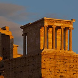
The remains of the Acropolis can be divided into three main areas. From Odeon of Herodes Atticus, we ascended to the entrance of the temple, The Propylaea. Before it was a flight of steps, a good place to admire this monumental gateway and take pictures. On the right, as we entered the Acropolis, was a small but graceful temple called Temple of Wingless Victory or Temple of Athena Nike overlooking the city.

Temple of Wingless Victory, Acropolis, Athens

the Propylaea, Acropolis, Athens

Passing through the gateway, on the left is a temple called Erechtheum. The most famous feature is its south portion, The Porch of the Caryatids. It is a porch whose supporting columns are built as six draped female figures (caryatid). All these caryatids in place are in fact replacements. The original pieces were moved to Acropolis Museum for restoration and display.

Erechtheum and  Porch of the Caryatids, Acropolis, Athens

The main temple of the Acropolis is Parthenon. This grandiose temple has transcended its architectural greatness and become the symbol of classic and perfection. It’s almost unimaginable that the temple maintained its shape until 1687 when a bomb was thrown into the temple as Turks used it as the ammunition and rendered the temple into the ruins as it is today. Parthenon was undergoing the second round of restoration project. Huge machineries were visible from any angle. It’s quite disturbing and impossible to take a shot of the whole temple.

Parthenon, Acropolis, Athens

Sitting on a flat-topped rock 490ft (150m) above the sea level, the Acropolis provides a fantastic view of its surrounding city. Compared with the temples and monuments that we had just visited in Egypt, the Acropolis didn’t impress us very much. It is not as old as the Great Pyramids, not as majestic as the Hypostyle Hall at Karnak and not as well-decorated as those tombs in Valley of the Kings. However, what makes it stand out is its symbolic meaning. The Acropolis is much more than a historical ruin, but a symbol of aesthetics, philosophy and value of Classical Greek culture, which is widely considered to be the foundation of modern western civilization. It is really amazing to imagine that Greek civilization at its Golden Age has reached such a pinnacle that people were doing and thinking things that no one tried to be doing and thinking for the next 1500 years.

City surrounding the Acropolis, Athens

Exited the Acropolis from its north gate, paid a small entrance fee, we entered the Agora (marketplace). It’s the political and cultural center of ancient Athens. Speeches were delivered here, law court, schools, and theaters were built here. It even had a mint and state prison. Hephaisteion is the best-preserved temple in the area and looking the Parthenon into the distance. Stoa of Attalos is a building with a long colonnaded walkway. It was reconstructed in the mid-20th and used as a museum now.

Church in Byzantine Style in the Agora, Athens

Hephaisteion in the Agora, Athens

Overlook the Acropolis from Hephaisteion, Athens

Stoa of Attalos in the Agora, Athens

The area surrounded the Acropolis and the Agora is called Plaka. It is a nice neighborhood but quite commercialized area mixed with small shops, cafes, churches and a few ancient ruins. It’s an easy and lazy afternoon as the sun was warm and many people sitting outside of the cafes on the street. The alleys are never straight, it is easy to get lost, but you can always look up and see the Acropolis then know where you are going.

Plaka, Athens

Plaka, Athens

We had a snap at the hotel then took the subway to Syntagma. We thought we could find high-end shopping district in this area, however, it’s indeed more like a city hub. The street we walked on were crowded but the shops were not very attractive. There was only one subway stop between Syntagma and where we live, so we decided to walk back and eventually we reached Plaka area. Again, we found the restaurants here were just typical tourist places, we enjoyed the environments rather than the quality of food.

Before going back to the hotel, we took a sidewalk to the Temple of Olympian Zeus. It is the largest temple in Greece, exceeding even Parthenon in size, however now only 15 columns remain standing, another one collapsed in 1852 and broke into pieces. The detail of the columns and the view of the Acropolis through the columns were very impressive, so I decided to pick up my tripod left in the hotel. As I went back to the temple, it started dribbling but soon stopped. A rainbow appeared in the eastern sky – a nice reward for my effort to take the tripod.

Temple of Olympian Zeus, Athens

Temple of Olympian Zeus, Athens

Temple of Olympian Zeus, Athens

The park closed at 7pm. When we passed Hadrian’s Arch, I noticed the arch was painted with the bright golden color by the sunset. My wife went back to the hotel by herself and I was almost running to the entrance of the Acropolis. I should have asked her to join me because she missed a once in a lifetime sunset scene. The last ray of the sun rendered the Acropolis and the surrounding city in the glorious colors, the color transited from golden to red to purple. Glory, that’s feeling filled my heart.

Hadrian’s Arch, Athens

the Acropolis in the Sunset, Athens

Athens in the Sunset

This was the last day of the trip. We left Athens the next day morning and arrived home at night. As I finally complete my travelogue, there are still a lot of more to be digested. It was such an unforgettable trip that we will be proud of for many years.

1 Comment

Greece – Santorini – Head to Toe

2010.10.15The wind stopped the next day and the sky was crystal clear. I walked down stairs to other hotels beneath us on the cliff. They have undisturbed view of the full circle of the caldera.

Hotel in Firostefani, Santorini

Caldera View, Santorini

Because it had been too windy and too many people at Oia the previous day, we decided to go there again in the morning. It’s only a 20-minute drive from Firostefani to Oia. One of the villas at the northern tip of the island claims to be “the most popular site for marriage proposals” – that might not be an exaggeration.

Oia, Santorini

Oia, Santorini

Windmill at the Northern Tip of Santorini

Coming back from Oia, We had lunch at another cliff restaurant. When we checked out the hotel, I asked the owner what he would do in winter. He said that he would close the hotel and go back to Athens in two weeks, and then he would come back to the island again the next year. Most hotels and restaurants will be closed in the low season. The owner told me that late May and early October were good time to visit the island, “you cannot imagine how crowded the street is in summer”.

Lunch in Firostefani, Santorini

Efterpi Villas, Santorini

Caldera View from the Balcony of Efterpi Villas, Santorini

Our flight was at 7pm. We still had a lot of time. For the past two days, we only drove around the cliff side, so we decided to see the other side of the island first. Unlike Corfu Island, Santorini is mostly barren. While the cliff is decorated with the dazzling white buildings, at the end of the slow slope going down from the cliff, there are all black sand beaches. We stopped at Monolithos beach, which has some strange sand stone formation. Only a few people on the beach, some of them took off their clothes. This might be one of the nude beaches on the island.

Sand Stone Formation at Monolithos Beach, Santorini

We continued driving sort of randomly. We drove around Emporio’s town square a bit, then at Akrotiri, we failed to locate its archaeological site. Sitting in the small booth by the beach, we figured this was still not the end of the road yet, so we decided to keep on driving to the very south of the island. Along the road, we could see the Caldera from another direction. Those white houses on top of the cliff became just a white line. There is a light house at the road end. It is called Cape Akrotiri. From head to toe, we covered almost the whole island.

Caldera View from the Southern Tip of Santorini

Light House at Cape Akrotiri, Santorini

We arrived at the airport before it’s getting dark. This was the fourth small airport we had been to in the trip, Luxor, Abu Simbel, Corfu and Santorini, their airports all have merely one building with no more than two gates. From here, we were going to the last stop of the trip, Athens.

Santorini Airport

2 Comments

Greece – Santorini – Firá & Oia

2010.10.14It’s already 10pm when we stepped out of Santorini Airport. Although it’s very late, there is only one road from the airport to Firostefani, where our hotel is located, very close to Santorini’s town center Fira, so we couldn’t miss it. As we were ramping up along the zigzag street, we realized we were climbing to the cliff top. We asked a local resident (who has a tiny cat:-) for direction and parked our car by a small church. The church’s shape and color was in typical Santorini style – white walls, blue domes and the tower bells. Passing through a narrow alley, stepping down a few stairway, here was our hotel, Efterpi Villas. I had never seen a hotel so compact, yet so elegant – it should only appear in fairy tale. In fact, all hotels around us were like this. The narrow alley that we passed by leads to the Fira along the cliff top. At 11pm, many people just walked back from the town. We had a dinner at a family restaurant by the cliff. The breeze was warm, you could smell the romance in the atmosphere.

Santorini

We waked up the next day morning with a perfect view of the island Nea Kameni, (the only thing less perfect was there was a power line running through in front of our window). The owner of the hotel cooked the breakfast and brought it to our room. Santorini is the remains of a massive volcano eruption around 1450 BC. Nea Kameni island in the middle of the crater emerged after very recent activities in 197 BC and 1707. After the devastating earthquake in 1956, Santorini’s central town, Fira, was rebuilt with churches, hotels and restaurants cling to the edge of caldera to enjoy the magnificent views. The view of white-washed wall and the blue-domed churches with the Aegean sea as the backdrop is so unique that anyone who sees the picture of Santorini for the first time cannot believe such a place does exist in this world.

Santorini

Santorini

From Room of Efterpi Villas, Santorini

After breakfast, we walked along the Agiou Mina street, the ally by the crater edge, to Fira. Fira is the hub of the Santorini island. Like other town centers of Greek Islands, its narrow streets are packed with small shops, restaurants and bars. We did some shopping, visited catholic quarter and had lunch at one of the restaurants. Octopus is a typical local dish but we didn’t expect it was so huge on the plate. The view was unbeatable. The only regret was that it seemed the bad weather followed us here, the sky was cloudy most of time.

Firostefani, Santorini

Fira, Santorini

Catholic Cathedral, Fira, Santorini

Catholic Cathedral, Fira, Santorini

Lunch, Santorini

Lunch, Santorini

By the afternoon, the wind gradually cleared the sky. We drove to the north of the island. It is said that the northern tip is an ideal place to watch the sunset. We passed an lovely square with a church and several shops, so we stopped to take pictures. One of the best scenes I saw on the island was a roof paved with white cobbles here. Looking over the roof, the sea was shining and the remote island became a little blurred. It’s one spectacular view I will never forget.

Oia, Santorini

Oia, Santorini

Oia, Santorini

Kept on driving for another 300 feet, I noticed a few tour buses dropped hundreds of visitors off at the parking lot. It meant there must be something worth seeing. We followed the tour group into the alley, until then we realized we were at the town Oia, where all those postcard photos are taken, not at Fira but here. The lighting of the afternoon sun was wonderful, but there were too many people, I had to wait in line to get a spot to take pictures or hold on several minutes for a view with less people in the frame.

Oia, Santorini

Oia, Santorini

Oia, Santorini

There were only a few restaurants and hotels at the very northern tip of the island. The sun was low. Many people were either dining or standing by the cliff to wait for the sunset. However, I found the cloud gathering at the horizon and getting darker and darker. I doubted very much that anyone could see the sunset so I took some photos at the windmills and left. While driving back to the hotel, the wind became very strong and the cloud was moving fast from the cliff side. At some points, the dark cloud was so dense that we couldn’t see the road. The fierce wind kept on blasting throughout the night. We fell into sleep accompanied by the whistling sound made by the wind blowing through the power line.

Northern Tip of Santorini

Northern Tip of Santorini

Northern Tip of Santorini

Greek Salad, Santorini

2 Comments