Tanzania – Lake Eyasi

2012.12.27Leaving Kirurumu Manyara Lodge at 10am, we continued driving to the south on B144. After half an hour, we reached a town. This is Karatu district, one of the six districts in Arusha region. This is Justin’s home town. We stopped by a store and he left something for his friend.

Karatu District
Karatu, Arusha Region of Tanzania.

Passing the town, drove for another 3 miles, we turned left on a dirt road towards Lake Eyasi.

T K Eyasi Rd.
T K Eyasi Rd., near Oldeani, Karatu District
Southern Ground Hornbill, T K Eyasi Rd.
Two Southern Ground Hornbills by the dirt road after we turned from Rd. B144 to T K Eyasi Rd.

The road was a little bumpy. It’s getting hotter as we went further south. There were no high vegetation, but only bushes here and there.

Barren land near Lake Eyasi
Massai Cottage near Lake Eyasi

After about an hour, we saw a hut at the roadside. This is the reception office of Lake Eyasi area. A man working in the office joined us in the jeep. He would be our guide to visit Hadzabe bushmen and Datoga tribe living in this area.

Reception office of visiting tribes in Lake Eyasi area
The reception office as we entered the Lake Eyasi area.

Keep driving for another 5 minutes, we turned off the road and drove into the bush. All Hadzabe bushmen live around Lake Eyasi. Their total population is under 1000. They are the only hunter-gatherers in Africa. There were several attempts to bring in other cultures or even administration to the group, but all failed. They still live today as they have lived for thousands of years. The current approach is to keep them informed about political events and make sure they receive fair treatment in this fast-changing world. Inevitably, the intrusion of tourism affects their traditional way of life, but on the positive side, more income offers more opportunities for their kids to get some education.

Hadzabe Bushmen Tribe, near Lake Eyasi
Women of Hadzabe Bushmen Tribe, near Lake Eyasi
Hadzabe Bushmen Tribe, near Lake Eyasi
A smoking men of Hadzabe Bushmen Tribe, near Lake Eyasi
Hadzabe Bushmen Tribe, near Lake Eyasi

It’s at noon of the day. Most men and women in the tribe just sitting in the shade. Some of them were smoking or making tools for hunting. They demonstrated some of their skills, such as making fire with hand drilling and bow shooting. The guide also showed us the rock that the bushmen use to shelter from rain and the tree that they use to display skulls of animals they hunted. At last, several young men and kids gathered in a circle, sung and danced together. The other thing that visitors can do is to hunt with them in the early morning. Most of time, they shoot down birds with their bows; very occasionally, they might be able to catch Baboons.

Hadzabe Bushmen Tribe, near Lake Eyasi
Making arrows, Hadzabe Bushmen Tribe, near Lake Eyasi
Hadzabe Bushmen Tribe, near Lake Eyasi
The hunter, Hadzabe Bushmen Tribe, near Lake Eyasi

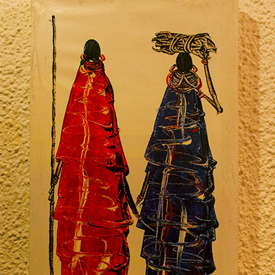
Left where Hadza people live, our next stop is to visit a family of Datoga Tribe. Their house was next to the main road, so I am not sure if they are real indigenous people or staged for tourists. Datoga men practice polygamy. All wives in the family came out to welcome us. We enter their cottage with very low roof and watched them grinding corn. At another side of the yard, we watched them melting bronze metal and making arrows. They also make bracelets for sale. The guide told us that they got their raw materials from nearby village. We saw them using bronze pipes. They already have access to these modern industrial objects, but they make them into arrows for primitive people. The fact itself is quite surreal to me.

A family of Datoga Tribe, near Lake Eyasi
Wives of a family of Datoga Tribe, near Lake Eyasi

We checked into Tindiga Tented Camp at around 2pm. Compared to the first two lodges, this camp is much more basic. The front desk was located in a small dining room. We were the only guests on that day.

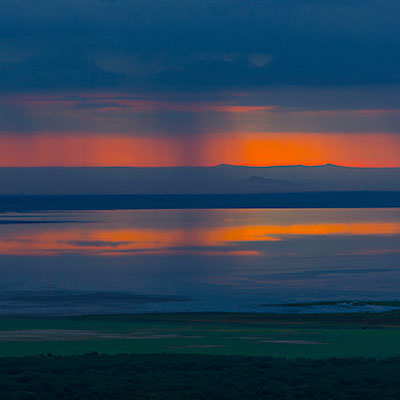
After having some rest, Justin took us to drive around the area. The jeep climbed to a nearby hill. At its east side, there were crop fields of the nearby villages; at the west, we could see Lake Eyasi about 1 mile away. Justin said the lake shore were all mud because of the rain and difficult to access,

Agriculture area near Lake Eyasi
Overlook Lake Eyasi
Overlook Lake Eyasi
Kids from the village followed us to the hill top, near Lake Eyasi

Justin wanted to show us how ordinary Tanzanians live, so we went to the Qaund’ded Village at the foot of the hill. We first stopped by a small pond – this is the water source of the village. Young men and women carry water from here for their daily usage. Most people didn’t mind me taking pictures, but one girl was unhappy about that, so I stopped.

Villagers carrying water from a pond by the village, near Lake Eyasi
Villagers carrying water from the pond, near Lake Eyasi
The water source of villages near Lake Eyasi
The pond is the only water source of the village, near Lake Eyasi
The girl was not happy about us taking pictures on them.
The girl didn’t like us taking pictures on them, near Lake Eyasi

We drove through the village. Justin said the climate of this area is good for growing crops and villagers work hard, but by looking at their shelters, these villagers must still live in deep poverty.

A village near Lake Eyasi
Qaund’ded village near Lake Eyasi
A village near Lake Eyasi
Qaund’ded village near Lake Eyasi

We had dinner together with Justin. We talked about various subjects, such as the interesting brotherhood relationship between China and Tanzania in the past; but mostly we talked about our everyday lives, the marriage tradition, education and so on. Justin was quite unhappy about western influence on Tanzania’s school system. He felt that kids now a day were so spoiled. He said if he had choice, he’d send her daughter to the school that allow corporal punishment!

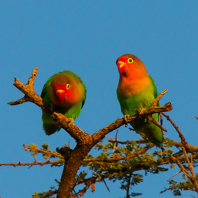
I was woken up by chirping birds the next morning. I had a walk around the camp. The morning sun was warm, not harsh yet. I got some good shoots on those birds.

Strange plant, Tindiga Tented Camp, near Lake Eyasi
Strange plant in Tindiga Tented Camp.
Tindiga Tented Camp, near Lake Eyasi
Tindiga Tented Camp.
Love birds, Tindiga Tented Camp, Near Lake Eyasi
Love birds, Tindiga Tented Camp.
Common Bulbul, Tindiga Tented Camp, Near Lake Eyasi
Common Bulbul, Tindiga Tented Camp.
0 Comments

Tanzania – Lake Manyara National Park

2012.12.26We left Tarangire National Park at 10am. Driving 3 miles on dirt road and a couple of miles on paved road to Arusha direction, then we turn left on B144. This is a section of straight high way. The landscape is open and dry, covered with sparsed low bush. The distance between Tarangire and Lake Manyara is not far. From here, we could already see the south part of Lake Manyara.

From Tarangire to Lake Manyara
From Tarangire to Lake Manyara.

After about an hour, we entered a populated area, Mto wa Mbu, which borders Lake Manyara National Park to the southeastern side. Justin took us to a nearby village. Crossing a banana field, we saw several farmhouses and thatched shacks. A shack was used to display handcraft and woodwork. Some locals were working on the new items, carving and polishing the wood sculptures.

Banana field near Mto wa Mbu
A banana field near Mto wa Mbu.
Village near Mto wa Mbu
Farmhouses in a village near Mto wa Mbu.

Tanzania is renowned for original and fanciful woodcarvings. They are also popular tourist souvenirs. One of men first gave us a short talk, telling the story about why their tribe moved from Mozambique and how they created these woodwork based on their dreams and their everyday lives. We were much more impressed by the way he talked than the story he was telling. He spoke slowly and calmly, with clear logic and great confidence – it’s a very persuasive sales pitch. He claimed the carvings were made by Ebony wood, but Achmed told us before we left Arusha, “whoever said it’s Ebony, it’s not”. We bought some paintings made by banana leaves.

Locals carving the wood near Mto wa Mbu
Locals working on woodcrafts.

We decided to check into the lodge before going to the Lake Manyara National Park. It’s hot at noon and animals are not active anyway. We passed by the park’s entrance and started climbing a steep hill – Graben and Half-Graben (from Wikipedia) we were actually escalading the western wall of the East African Rift Valley. Unlike the river valley or glacier valley, the rift valley is not created by erosion but by tectonic plates pulling apart from each other. Horsts and Grabens are often produced along the parallel faults. In the section of Rift Valley, the geological structure appears to be a half-graben, where the valley’s western wall rises 2000 feet high on one side and a flat lowland on the other side extended to as far as eye can see. Lake Manyara lies right at the foot of the wall.

There are several souvenir stores along the road. Tingatinga style paintings were displayed outside the store; inside, thousands woodcraft items, from two-inch-long statues to full-sized monkeys and buffaloes, were packed on the shelves. We picked three foot-long figures and bargained for about 40% discount of what they originally asked for. Even at this price, the store could easily worth hundred thousand dollars.

Handcrafts and wood craving store near Lake Manyara.
Woodcarvings displayed in a souvenir store near Lake Manyara.

After lunch, we checked into our hotel, Kirurumu Manyara Lodge. The lodge sits on the rim of the Rift Valley. From its entrance, the paved alleys split into branches. Each branch leads to a tent cabin surrounded by woods, yet every tent has a view of Lake Manyara.

Kirurumu Manyara Lodge
Our room in Kirurumu Manyara Lodge
Overlook Lake Manyara National Park
Overlook Lake Manyara from the patio of our cabin. There was a thunderstorm over the lake.

At 4pm, we climbed down the Rift Valley to the park. Once we entered the park, the dry and hot air was suddenly behind us. The temperature seemed to drop several degree at least.

Thunderstorm near Lake Manyara National Park
There was a huge thunderstorm at the direction of Mto wa Mbu. Lucky we were not caught by it. Lake Manyara.

Because of abundant water source, unlike Tanragire National Park, most of Lake Manyara National Park is covered by lush forest. The game drive road winds through the jungle. Not far from the entrance, at the northeast end of the park, there is a small pool called “Hippo Pool”. We could only see one hippo from far away, but Justin assured us that we would see plenty of them in Serengeti. Along the road, baboon troops haunt the dense woods or lounge on the open ground. The park is also a good place to view birds and eagles.

Game drive in Lake Manyara National Park
Game drive in Lake Manyara National Park.
Blue Monkey, Lake Manyara National Park
A blue monkey on the tree, Lake Manyara.
Sausage trees, Lake Manyara National Park
Sausage trees, Lake Manyara.
Silvery-cheeked Hornbill, Lake Manyara National Park
A Silvery-cheeked Hornbill, Lake Manyara.
Blue-ball monkey, Lake Manyara National Park
An unclear capture of a blue ball monkey, Lake Manyara.

Game drive road in Lake Manyara National Park is a loop. Contrasting to the forest in the north, the southeast of the park is the grassy floodplain. More animals were visible.

Lake Manyara National Park
Zebras in Lake Manyara National Park with the Rift Valley escarpment as the backdrop.
Dik-dik, Lake Manyara National Park
Dik-dik, Lake Manyara National Park.
Lake Manyara National Park
A giraffe wandered in the low bush, Lake Manyara National Park.
Lowland in the south end of Lake Manyara National Park
Lowland in the south end of Lake Manyara National Park.

We retired to our lodge after spending about two hours in the park. On our way back, I took several pictures of sunset at a vista point by the rim of the Rift Valley.

Sunset over Lake Manyara
Sunset over Lake Manyara.
Great Rift Valley
The Rift Valley.
Serengeti Beer, dinner at Kirurumu Manyara Lodge
Serengeti Beer, dinner at Kirurumu Manyara Lodge.

The next morning, I got up at 6am. Next to the dinner area, the platform in front of the lodge’s bar has a great view of Lake Manyara. Just like the previous day, the sky was covered by the heavy cloud; also like the previous day, the cloud opened a long and narrow gap at the horizon. If the sunrise at Tarangire was splendid, the sunrise over Lake Manyara had a sense of mystery.

Sunrise and thunderstorm over Lake Manyara
Sunrise and thunderstorm over Lake Manyara.
Sunrise over Lake Manyara
Sunrise over Lake Manyara.
Lake Manyara National Park Map
Map of Lake Manyara National Park.
0 Comments

Tanzania – Tarangire National Park

2012.12.25~26We checked out from our lodge in the morning at 8:00am. After exchanged some cash at Arusha’s city center, we headed west to Tarangire National Park.

Half an hour later, we already left the majestic Mt. Meru behind, now we were surrounded by the open plain dotted with Maasai villages. The village normally consists of several thatched huts with low roof and a cattle or sheep pen. As Justin and us got more familiar, our topics of discussion started touching things of his life, such as his family and what he did for living. He became very angry when he told us about the government corruption and unfairness in the society. He is quite a passionate person.

A Maasai village by the lake
A Maasai village by the lake, on the way to Tarangire from Arusha.

It has been very cloudy since we left Arusha. Rain started about 1 hour after we were on our way and soon became a downpour. There are two rainy seasons in Eastern Africa. November and December is supposed to be a minor one. However, according to Justin, there was a drought in November this year and it only started raining in late December, so we saw higher than normal precipitation at this time of the year. The rain was so heavy so that many ponds and creeks came to live along the road. The good thing is that this kind of rain normally doesn’t last long, and most part of the road were well paved, we didn’t have any trouble to get to the park at 10:30am.

Maasai herders
Maasai herders, on the way to Tarangire from Arusha.

The area is scorching hot in the dry season. Animals migrate into the park along the Tarangire River, which is the only permanent source of water year around. It’s the greatest concentration of wildlife outside the Serengeti ecosystem. During the rainy season, most animals scatter over the region but elephants stay. Elephants and Baobab Trees are two huge creatures that can be commonly seen in the park.

Elephant, Tarangire National Park
The most spectacular feature of Tarangire is its largest population of elephants.
Abdim's Stork, Tarangire
An Abdim’s stork near the entrance of Tarangire National Park.

We were surprised to see ostriches in the park. In fact, ostriches are native to Africa and only farmed in Australia. Here, they are doing “pair dancing”.

Visitors in Tarangire National Park
Visitors in the Safari tour, Tarangire.

Our plan was to have a short game drive, and then have our lunch before checking into the campsite. The landscape was getting more beautiful as we approached the Tarangire River. Wide panoramas of open Acacia woodland, rolling savanna studded with Baobab Trees, our jeep drove right into it. I was so excited and almost wanted to shout it out. This is exactly what I imagine Eastern Africa to look like!

Tarangire National Park Landscape
Landscape of Tarangire National Park.
Game drive in Tarangire National Park
Game drive in Tarangire.
Flooded Tarangire River because of the early rain, Tarangire National Park
Tarangire River flooded over the bridge because of the early rain.

The picnic area sits on top of a hill overlooking the Tarangire River. We had the same lunch box as the earlier day. We saw people from different countries, China, India and Arabic regions. Some of them were on the day-tour from Arusha. Human’s activities also attracted a group of black-faced vervet monkeys. They were just as aggressive as those in Mount Emei.

Black-faced Vervet Monkey, Tarangire National Park
A group of black-faced vervet monkeys at the picnic area, Tarangire.
Centipede, Tarangire National Park
A huge centipede on the ground of the picnic area, Tarangire.

Tarangire Safari Lodge is one of tens of “luxury camps” established in Eastern Africa national parks. These camps run just like hotels, except the visitors live in tents instead of rooms. The tent is spacious and it has private bath and toilet attached to it. The quality of these luxury camps varies widely. Tarangire Safari Lodge is by far the best one we lived in.

The lodge is situated on a panoramic bluff. We were impressed once we step into the the lounge, which is also served as the lodge’s lobby. The open design offers 180 degree unobstructed view of the Tarangire River valley. All tents are build along the cliff so you can just sit in front of your tent and watch elephants, giraffes and impalas coming to the river or playing over the wide plain.

Tarangire Safari Lodge
The open lounge of Tarangire Safari Lodge.
Tarangire River
Overlook Tarangire river from Tarangire Safari Lodge.
Camps in Tarangire Safari Lodge
Our tent in Tarangire Safari Lodge.

It’s hot and the sun is harsh at noon. We rested in the tent and went out again for game drive at 4pm. As we crossed the same bridge over the Tarangire River again, we found that the flooded river a couple of hours earlier now almost dried out.

Tarangire National Park
Palm trees by the Tarangire River.
Termite mounds, Tarangire National Park
Termite mounds, Tarangire.

Whenever you see several jeeps stopping by the road, it never hurts to stop and check too. This time was different – there were more than 20 vehicles lining together but we couldn’t see a thing. After asking other drivers, Justin told us that there were two African hunting dogs lying under the tree at distance. This is an endangered specie. There are only two groups of them in activity in northern parks of Tanzania. We were very lucky.

African Hunting Dog, Tarangire National Park
A pair of very rare African Hunting Dogs, Tarangire.

Another interesting scene we encountered later was a group of elephants drinking water and having fun around a pond. Sometimes they enjoyed the water maybe too much, they, especially the young ones, need some extra help to get out of the pond.

Because of the vast open space and the dramatic change of temperature in a day, the weather varies from time to time and from place to place in the park. While driving in the park, we often saw dark cloud gathered at somewhere far and the rain blurred the line between the cloud and the ground. After the thunderstorm, there was a rainbow. I asked Justin to stop the car and took these pictures. We were in awe of nature’s beauty!

Cloud in Tarangire National Park
The dramatic shape of cloud and the open wildness in Tarangire National Park.
Elephants under the rainbow, Tarangire National Park
Elephants walking under the rainbow, Tarangire.
Elephants, Tarangire National Park
A large group of elephants moved in the dusk of Tarangire National Park.

None of the campsites has wall or fence. It can be visited by wild animals. After dark, the camp has its personnel to escort visitors between the dining area and their tents. Living in the tent is comfortable. Secure the zippers of the tent and apply the repellents, we were not bothered by mosquitoes at all.

We planned to leave early the second day for game drive, but the sunrise was just too spectacular to miss. The thick and dark cloud covered the whole sky, except a narrow gap at the eastern horizon. The sky was burning red as the sun rose. It’s violent yet brilliant.

Sunrise in Tarangire National Park
Sunrise in Tarangire National Park.
Tarangire Safari Lodge
Tarangire Safari Lodge was bathed in the warm light of sunrise.

We left the campsite at 6:30am. Only 200 yard out, we saw 9 lions in the bush. They seemed alert and gazing out over the open field outside the bush. One after another, quietly and in an organized manner, they walk out of the bush. Justin jumped on to the jeep, trying to see what their target is, he said their move normally meant they were ready to attack, but he couldn’t see anything. A couple of minutes later, these lions seemed to lose their interest. They sit down and eventually all lied down on the ground. What a group of lazy cats!

Lions in the bush, Tarangire National Park
A group of lions hidden in the bush not far from the lodge, Tarangire National Park.
Lions, Tarangire National Park
Once they moved out of the bush, they seemed to lose their target, Tarangire National Park.
Lions, Tarangire National Park
Every move that lions made can be found in cats, Tarangire National Park.

We drove to the picnic area again. It’s early, there were nobody but us, and some groups of impalas and Thomson’s gazelles running around, enjoyed the morning. As we were about to leave, Justin spotted something unusual far across the river – there was a lion on the tree. Trees are normally leopard‘s territory in Eastern Africa, not lions’, but this lion looked quite conformable on the tree.

Lion lying on the tree, Tarangire National Park
A lion lying on the tree near the picnic area, Tarangire National Park.

What dominates the park is still elephants. They can get very close to the vehicle, within 20 feet. Although most of time peaceful, they can become aggressive if irritated, especially when they are with their calves. If you are faced with adult elephants, you’d better give them the right of the way, even you are in a car.

A baby elephant, Tarangire National Park
A baby elephant with the family, Tarangire National Park.
Baobab Trees are regarded as tree of life, because they are capable of providing shelter, food and water for animals and humans. Mature Baobabs are often hollow, their trunk skin from the ground up to 10 feet high are mostly gone. This is because Baobab Trees keep water in the trunk during the wet season for themselves to get through the dry season, but elephants know this trick and they peel off Baobab’s skin to get water. In the dry season, Baobab Trees lose all their leaves to preserve moisture. The tree is like it is planted upside down with its roots sticking up in the air.
Boabab tree, Tarangire National Park
A Baobab Tree with hollow trunk in Tarangire National Park.
Baobab Trees in Tarangire National Park
Baobab Trees in Tarangire National Park.
Tarangire National Park Map
The map of Tarangire National Park.

We returned to our lodge after 3 hours game drive and checked out at 10am. We were heading to our next destination, Lake Manyara National Park.

0 Comments

Tanzania – Arusha National Park

2012.12.24Justin picked us up at the lodge at 8:30am in the second morning. Our safari tour officially started from Arusha National Park.

Jeeps for safari tour, Ilboru Safari Lodge, Arusha, Tanzania
Jeeps for the safari tour waiting for the guests at Ilboru Safari Lodge. The leftmost one is ours. The plate number cannot be better.

The perimeter of Arusha National Park is only several miles to Arusha, but its main gate is about 40 miles away from the city. Although the size is small, the park has diversified geographical features, including Mt. Meru, Merella lake, forest and grassland over the Ngurdoto Crater. About an hour later, we parked our car at the entrance. While Justin was checking in at the office, we saw several giraffes walking in a bush about 200 feet from us. It’s our first wildlife encounter in Africa, understandably we were quite excited.

Giraffes at the entrance of Arusha National Park, Tanzania
Giraffes at the entrance of Arusha National Park.

The entrance gate leads into shadowy forest. We started seeing more animals, including groups of zebras and buffaloes.

Game drive at Arusha National Park, Tanzania
Game drive at Arusha National Park.
Zebras, Arusha National Park, Tanzania
A group of zebras, Arusha National Park.

We stopped at a ranger station near Tululusia Hill. One good thing about Arusha National Park is that, while visitors are not allow to leave their cars in other national parks, they can hike in Arusha National Park, accompanied by rangers with shotguns. Justin introduced us to one ranger, bigger group will have more rangers to walk with them. The rangers are guides at the same time. They are quite knowledgeable about plants and animals in the park.

The Whistling Thorn tree, Arusha National Park, Tanzania
The Whistling Thorn tree. This is giraffes’ favorite food. Although the thorns are long and sharp, giraffes prefer the leaves over grass, partly because they have to put their heads way down to get to the grass, which makes them more vulnerable to attacks.

We walked along a dried creek into the Buffalo Glade, an open area surrounded by forest. A group of buffaloes were at the edge of the woods. As we walk towards them, the ranger kept reminding us not to get too close, not to stare at them for too long. He said there were two times in the past that he had to warn then fire at buffalo when the visitors entered the flight zone and the buffalo started charging.

Buffaloes at Buffalo Glade, Arusha National Park, Tanzania
Buffaloes at Arusha National Park. It seemed we already got their attentions.

Leaving buffaloes behind, we kept walking across the glade. At the other end of the grass, we met three persons just climbing down from the mountain. One visitor had only a pro-camera in his hand and the other two locals carried other equipment and camping stuff for him. This is a typical format of hiking tours in Tanzania and Kenya. In some programs, such as climbing Kilimanjaro, the tourists are accompanied by even more locals.

Buffalo Glade, Arusha National Park, Tanzania
Buffalo Glade, Arusha National Park.
A Zebra skeleton at Buffalo Glade, Arusha National Park, Tanzania
A zebra skeleton at Buffalo Glade, Arusha National Park.

We entered the shade area of Tululusia Hill. A walk on the rocky trail rewarded us with something quite unexpected, a 28-meter water fall.

Rangers at Momella-Tululusia Waterfall, Arusha National Park, Tanzania
Rangers at Momella-Tululusia Waterfall, Arusha National Park, Tanzania.
Momella-Tululusia Waterfall, Arusha National Park, Tanzania
Momella-Tululusia Waterfall and roots of a fig tree, Arusha National Park, Tanzania.

We turned back and walked along the foot of the hill. In the middle of the woods, we saw a giraffe under the Acacia Tree eating leaves, calm and elegant. My wife happily had some pictures with the giraffe.

A Giraffe at Buffalo Glade, Arusha National Park, Tanzania
A Giraffe under the Acacia Tree, Arusha National Park, Tanzania.
Bushpigs at Buffalo Glade, Arusha National Park, Tanzania
Bushpigs at Buffalo Glade, Arusha National Park, Tanzania.
A fig tree, Arusha National Park, Tanzania
A fig tree, Arusha National Park, Tanzania.

We walked for about 2 hours and returned to the ranger station at 1:30pm. Justin and us sit down in an open hut to have our lunch. What’s in the lunch box are almost same every day and same for all different tour groups. It normally contains a fried chicken leg, a piece of bread, an apple, a bottled drink and some bagged peanuts. Every morning, the camping sites prepare the lunch box and give them to the guide. They are not very fresh, but the chicken was always tasty.

It started raining as we were having the lunch. Lucky that we didn’t try to climb the hill, which is normally part of the program. We resumed our game drive to the east in the rain after lunch. Some animals were using bushes to shelter from the rain.

A male Waterbuck in the rain, Arusha National Park, Tanzania
A male waterbuck standing in the rain, Arusha National Park, Tanzania
A Bushbuck found shield under the Whistling Thorn tree, Arusha National Park, Tanzania
A bushbuck found shelter under the Whistling Thorn tree, Arusha National Park.

The rain stopped as we were approaching Momella Lakes. This is a group of lakes that are fed by underground water. Different mineral not only give lakes different colors but also support many types of waterfowls. The most attractive ones among them are certainly flamingos. They gathered along the lake as if to embroider the lake with the pink border.

Greater Flamingo, Arusha National Park, Tanzania
Greater flamingos. The clear distinction to lesser flamingo is that the greater flamingo’s bill is mostly pink. Arusha National Park.
Flamingos at Small Momella Lake, Arusha National Park, Tanzania
Flamingos at Small Momella Lake, Arusha National Park.

We circled around the Big Momella Lakes. At its north side, hundreds of lesser flamingo standing in the still water. I reduced the exposure time to darken the water in the hope of creating an abstract theme. To me, the image of Africa safari has always been endless savanna, vast, wild and sometimes brutal. These tranquil lakes with flamingos revealed a peaceful and soft side that we didn’t expect.

Big Momella Lake, Arusha National Park, Tanzania
Big Momella Lake, Arusha National Park.
Lesser Flamingo, Arusha National Park, Tanzania
Lesser flamingo – their bills are in dark color. Arusha National Park.
Collared Sunbird, Arusha National Park, Tanzania
Collared sunbird, Arusha National Park.

Arusha National Park is located in between Mt. Meru and Mt. Kilimanjaro. On our way back, we first stopped at a vista point that can view both of these two mountains. Only 40 miles from Mt. Kilimanjaro (19,341 ft), Mt. Meru (4,977 ft) is the second highest mountain in Tanzania, and a dormant volcano dominating the park and the city. In the eruption about 8000 years ago, Mt. Meru lost much of its bulk on the east side and created the dramatic terrain of Arusha National Park. The hollow center couldn’t support the huge body, several collapse ensued. In a clear day, one can see Mt. Kilimanjaro from Mt. Meru. Unlucky to us, the Kibo Summit of Kilimanjaro was blocked by the cloud.

Mt. Meru, Arusha National Park, Tanzania
Mt. Meru, Arusha National Park.
Panorama of Arusha National Park, Tanzania
Panorama of Arusha National Park. Mt. Meru is on the left. On the right, we could only see the northwest slope of Mt. Kilimanjaro.
An African Hawk Eagle, Arusha National Park, Tanzania
An African hawk eagle, Arusha National Park.

We made a brief stop at an one-room museum near the park’s gate. Moving further, we encountered a troop of baboon walking directly towards us. They are large size old world monkeys that can be commonly found in Africa. At one point, we also saw a colobus monkey on the tree, but I didn’t have a good shot of it.

Baboons, Arusha National Park, Tanzania
Baboons at Arusha National Park
Arusha National Park Map
The map of Arusha National Park

We left the park at about 3:30pm. We saw several coffee plantations on our way back to the city. Coffee is Tanzania’s largest export crop. These plantations still employ the traditional shade-grown cultivation, in contrast to sun cultivation, which yield more coffee. Shade-grown coffee is considered superior in quality and causes less environmental issues, thus, more “organic”.

Coffee plantation near Arusha, Tanzania
A coffee plantation near Arusha, Tanzania
1 Comment

Tanzania – Arusha

2012.12.23~24The decision to visit Tanzania at the year end was really made during Thanksgiving holidays. It’s possible to get ready in such a short time is because I already did my research and had contacted several travel agencies, especially the one we finally chose, Base Camp Tanzania, when we struggled between the trip to Antarctica and Eastern Africa a year early. The trip was confirmed only a couple of days after Thanksgiving and we were on our way three weeks later.

Our trip started at Arusha, which is served by Kilimanjaro International Airport for international travelers. KLM is the only major airline offers direct flight to the airport. It was our longest connecting flights so far. We had totally 21 hours in the air. Layover time was shorter than our other trips, but we were lucky that there was no major delay and we arrived at JRO at 9pm local time on Dec. 23rd.

We met our guide, Justin, at the airport. He has a tall and strong figure and looks very humble. He will be our only guide and driver for the next 9 days. From the Airport to Arusha, the road was mildly uphill most of time, Our car was particularly slow. This 35-mile took us almost one and half hours. After we entered the town, the car turned off the main street to a very rough dirt road. We were tossed up and down for another 10 minutes. As we started wondering what this seemingly endless bumpy road would lead us to, we arrived at our destination, Ilboru Safari Lodge.

We had a room in round shape, probably modeled after the Maasai huts. It soon started raining. There were some small issues with the room, such as the shower and power outlet, but the room was spacious and comfortable. Although it’s already dark when we checked in, I could feel that we were surrounded by lush plants. The next morning, I had a chance to walk around the garden.

Rooms in Ilboru Safari Lodge, Arusha, Tanzania
Our room in Ilboru Safari Lodge, Arusha, Tanzania
Ilboru Safari Lodge, Arusha, Tanzania
Garden and pool in Ilboru Safari Lodge, Arusha, Tanzania
Ilboru Safari Lodge, Arusha, Tanzania
Front yard of Ilboru Safari Lodge, Arusha, Tanzania
Breakfast at Ilboru Safari Lodge, Arusha, Tanzania
The breakfast, Ilboru Safari Lodge, Arusha, Tanzania

Arush is the capital city of the Arusha Region of Tanzania. We didn’t have opportunity to spend time in the city, but merely passing through the city center several times on our car. Although the city is a political hub for Eastern African international issues, Arusha remains a small and rural town. However, it doesn’t mean it’s not vital – a lot of people on the streets and the roads are jammed by cars during rush hours, especially the only one road coming in and out of the town. Compared to the busy town outside, the lodge is like an oasis.

After coming back from Arush National Park on our first day, the owner of our tour company, Achmed, came to visit us. He helped us setup the tour in very short time and was very responsive to all our questions. He is a British man who is also half German and have lived in Tanzania for more than 20 years. We had a beer in the lodge’s German Beer Garden. Achmed went over our itinerary and noted special features of each park. He also stressed that if we wanted to go to the toilet while in safari, just go to the back of the jeep, instead of hiding behind the bush. Still recovering from the time difference, we could barely keep our eyes open lately. There is one thing I still remember – the reason he prefers living in Tanzania, given the government corruptions and lower living conditions, is because “there is no puppet law in this country”.

At the dinner, the waitress obviously forgot that we didn’t have the dinner the previous night because we came too late, but we managed to get their local Swahili cuisine that only offers to the guests on their first night. The dinner came in as small dishes, including Machalari, Ugali (maize flour paste), Sukuma Wiki, beef stew and barbecue plates. The food were quite salty, some of them had tastes of Indian dishes.

Swahili dishes at dinner, Ilboru Safari Lodge, Arusha, Tanzania
Small Swahili dishes at dinner, Ilboru Safari Lodge, Arusha, Tanzania
0 Comments

Alaska – Denali National Park

2012.8.31~9.1We resupplied at Fred Meyer supermarket and left Fairbanks to Denali National Park in the morning. We drove west on AK-4. It soon became George Parks Highway (AK-3) once we were out of the city. Connecting Anchorage and Fairbanks and providing the major access to Denali National Park, George Parks Highway is one of the most important roads in state Alaska. However, the mountain range around the area is mild and the road side view is less dramatic compared to the Richardson Highway.

George Parks Highway, Alaska

We reached Nenana at the noon time. This is a small town 55 miles south of Fairbanks, at the juncture of the Nenana River and the Tanana River. The discovery of gold in Fairbanks brought prosperity and train access to the town, but it had no road access to Fairbanks until the bridge was constructed in 1968. The completion of George Parks Highway in 1971 gave the town a direct route to Anchorage. We made a brief stop at the railway station and a gift shop in the town.

Mears Memorial Bridge over the Tanana River, Nenana, Alaska
Nenana, Alaska
Nenana, Alaska

it’s been cloudy all the way since we left Fairbanks. At about 1:30pm, we entered Denali National Park and Preserve area. Only 1 mile north to the park’s entrance, overlooking the Nenana River, there is a large area full of lodging and restaurant options. It has maybe the only traffic light in the whole stretch of the George Parks Highway. We took a quick stop and decided to see the park first before going to our lodge.

Near Denali National Park, Alaska
Nenana river, between Healy and the entrance of Denali National Park, Alaska

We picked up our tour ticket for the next day at the Wilderness Access Center and stopped by the Denali Visitor Center. They are located at the beginning of the Park Road. The first 15 miles of the Park Road is open to private vehicles. We came to Alaska in late tourism season in September, which sees more rains, but also offers unbeatable view of fall colors and tundra field. A couple of miles into the park, we found ourselves surrounded by the seemingly endless red and purple sea of tundra. Tundra is dwarfed shrubs adapted to the short growing season. They blossom in August and turned to brilliant colors in the fall.

Denali National Park, Alaska
Tundra panorama in Denali National Park dotted by spruces, Alaska
Denali National Park, Alaska
Fall color of Denali National Park, Alaska
Denali National Park, Alaska
Fall color of Denali National Park, Alaska

It’s a good decision to see the park first. It started raining at the time we turned back at about the 12 mile mark. Our lodge, McKinley Village Lodge, is 7 miles south of the park entrance. It’s a large facility with multiple buildings. The lobby was warm and cozy. The lodge was built along the Nenana river bank. One of our rooms got the river view.

The section of Nenana River where McKinley Village Lodge is located, Alaska

Our Denali National Park bus tour started at 7:30am the next day. We waited at the Wilderness Access Center half an hour before the shuttle bus came to pick us up. We chose the tour that reaches Eielson Visitor Center that is located at Mile 66 of the park road. The round-trip time is about 8 hours. It’s a good duration considering that we had to keep some strength to drive back to Anchorage at the night. The furthest point that the shuttle bus can take you is Kantishna at Mile 92, but most visitors who are willing to go that far probably camp at Wonder Lake at Mile 85.

The sighting is generally better if you sit on the left side of the bus, which offers more open views of the river and the valley on the way going into the park. It’s also more “scarier” when the bus runs on the cliff at some section of the road. On the way back, you would most likely fall asleep anyway. Our guide was funny. He almost keep talking all the way without stop. The tour is somewhat disappointing mainly because of the weather. We had a grey day and animals were rare. We didn’t see Mt. McKinley at the Eielson Visitor Center because of the cloud. (The rangers also kept us inside because some bears were around.)

Denali National Park, Alaska
Tundra in wonderful display as we just passed the check point where private vehicles have to turn back, Denali National Park, Alaska
Denali National Park, Alaska
The park offers hiking options in the total wilderness, Denali National Park, Alaska
Stony Hill Overlook, Denali National Park, Alaska
At Stony Hill Overlook where we should supposedly see Mt. McKinley in a clear day, Denali National Park, Alaska
Denali National Park, Alaska
Only tundra no taiga near Eielson Visitor Center, Denali National Park, Alaska
Bears, Denali National Park, Alaska
A bear with her two cubs, Denali National Park, Alaska
Bull Moose, Denali National Park, Alaska
A Bull Moose near the entrance of Denali National Park, Alaska

We returned to the Wilderness Access Center a little before 4:00pm. We left the park immediately – we had 240 miles to drive to get to Anchorage. The rain stopped and started. It’s raining very hard near Wasilla. Somehow we managed to beat the time to step into the VIP Korean restaurant that we liked so much before its close. (We ordered the food while driving as we were approaching Anchorage).

We had some time to stop by the University of Alaska Anchorage in the next day morning, before we took the flight heading home at noon.

2 Comments

Alaska – Fairbanks

2012.8.30Fairbanks is located in the Alaska Interior, half way between the Gulf of Alaska and Arctic Ocean. It’s second largest city of the state. At latitude of 64 degree north, Fairbanks’ summer sees long hours of sun light, but as it enters September, the daytime is shortened by an hour every week. The winter is long and cold. The temperature can often reach −30 °F. However, locals don’t see it as an inconvenience. They wear heavy coats with only T-shirts inside, so they can quickly adjust to the difference between the indoor and outdoor temperatures.

We came to Fairbanks with very little expectation to see Aurora – the northern lights. The auroral activity was only 1 or 2 for the two nights that we were there. Because Fairbanks is in the central of Tanana Valley, the sky is often cloudy in the night. It’s said that the chance is better if you drive north away from the city and up to the mountains. Some lodges there also offer the Aurora Viewing programs with hefty price. As I knew the chance was very low in September, other than opening the window to watch the sky from time to time, we didn’t do anything.

In the morning, we first went to the Trans-Alaska Pipeline visitor center, which is located only 10 miles north of Fairbanks. The pipeline is one of the largest projects of its kind. Although controversial, it’s truly a man-made wonder and solved many difficulties to deal with permafrost and earthquake faults to being financially and environmentally feasible.

Trans-Alaska Pipeline visitor center, Fairbanks, Alaska

We then went to see the Georgeson Botanical Garden. It’s a lovely garden with many species, which is specially challenging consider Fairbanks’ northern environment. The garden is within University of Alaska Fairbanks’ campus and serves as the field ground to study subarctic horticulture.

Georgeson Botanical Garden, Fairbanks, Alaska
Huge cabbage in Georgeson Botanical Garden, Fairbanks, Alaska
Georgeson Botanical Garden, Fairbanks, Alaska
Different species of wheat in Georgeson Botanical Garden, Fairbanks, Alaska
Alaska Berries, Georgeson Botanical Garden, Fairbanks, Alaska
Berries of Alaska, Georgeson Botanical Garden, Fairbanks, Alaska

We drove back to the main campus of University of Alaska Fairbanks and walked around the Museum of North.

University of Alaska at Fairbanks, Alaska
University of Alaska at Fairbanks’ campus, Alaska
University of Alaska Museum of the North, Fairbanks, Alaska

There are not many choices for restaurants in Fairbanks, but a Japanese Restaurant with a very plain appearance named Ajimi is one of the best.

Our first stop in the afternoon is Morris Thompson Cultural & Visitors Center located in the downtown. There were some informative displays and video here. It’s a good free “museum” to spend a hour or so. After that, we went to the Pioneer Park. It’s a park that was built to celebrate the 100th anniversary of the purchase of Alaska from Russia. Later, some old cabins were moved to the place and it has became a historic park that mimics a gold-rush town and demonstrates living environments of the early settlers.

Pioneer Park, Fairbanks, Alaska
0 Comments

Alaska – Anchorage to Fairbanks

2012.8.28~29From Anchorage to Fairbanks, we would take Glenn Highway (AK-1) and then Richardson Highway (AK-4 and AK-2). We’d go to Denali National Park later in our trip, At that time, we would go back to Anchorage by the shorter route, AK-3, to complete a loop.

The first 40 miles of the Glenn Highway is the only road access to Anchorage from the north. After this section of the busy road, as we turned east after passing Palmer, the vehicles were getting fewer and fewer. The highway runs along the south side of the Alaska Range and, for the most part, along the Matanuska River. The road is winding and climbs over Eureka Summit at 3,332 ft. There are many pullout places for you to view the beautify valley created by the receding Matanuska Glacier.

Mountain range by the Glenn Highway, Alaska
Mountain range and glacier lakes by the Glenn Highway, Alaska
Matanuska Glacier, Alaska
Matanuska Glacier, about 100 miles north-east of Anchorage, Alaska

The 180-mile Glenn Highway took us almost 5 hours. We stayed over night at Caribou Hotel in Glennallen. Some travelers gave low rating to the hotel, but we found it to be nice and most importantly clean, and the front desk was very helpful too. It’s not cheap, but this is in the middle of nowhere, I don’t think you should expect full facilities.

Mount Drum, Glennallen, Alaska
Overlook Mount Drum from Glennallen at sunset, Alaska
Caribou Hotel, Glennallen, Alaska

The next morning, I went back 10 miles along the highway and found the beautify lake we passed by the early night. The view was wonderful in the sunrise.

A lake in Sunrise, near Glennallen, Alaska
A lake in sunrise, 10 miles west to Glennallen, Alaska

After having some instant noodles as our breakfast, we were on our way at 9:30am. After 2 miles, we turned left onto the Richardson Highway (AK-4). The highway cut through the Alaska Range at its east end, the view continued to be breathtaking.

Richardson Highway (AK-4), Alaska
Summit Lake on Richardson Highway (AK-4), Alaska
Richardson Highway (AK-4), Alaska
Richardson Highway (AK-4) near Summit Lake, Alaska
Trans-Alaska Pipeline, Richardson Highway (AK-2), Alaska
Most of time, Richardson Highway run parallelly with Trans-Alaska Pipeline. This is one crossing section (63° 44′ 47″N, 145° 50′ 30″W)

AK-4 meets AK-2 at Delta Junction. There are several military bases around the area. Driving through the town, we surprisingly saw a sign as “Chinese Food”. We decided to give it a try. Luckily, it’s eatable. It’s about 3pm, we were 100 miles away from Fairbanks. As we had passed Alaska Range, the view along the road is less impressive.

15 miles south-east to Fairbanks, lies a small city, North Pole, Alaska. After driving the whole day, it felt good to see a meaningful city. Thanks for city’s name, a gift shop named Santa Claus House becomes a popular attraction. We made a stop at the store. It’s a nice place. There was a Santa taking pictures with visitors all the time.

Santa Claus' House, North Pole, Alaska
Santa Claus House, North Pole, Alaska

We reached Fairbanks at around 6pm. We would stay two nights in the city.

0 Comments

Alaska – Seward to Anchorage

2012.8.27~28The second day morning, we did some souvenir shopping and had a walk in the Waterfront Park before setting off to the Exit Glacier.

Waterfront Park, Seward, Alaska
View the Resurrection Bay from the Waterfront Park, Seward, Alaska
4th Ave., Seward, Alaska
Seward’s main street, 4th Avenue, Alaska

Exit Glacier is the only part of Kenai Fjords National Park that can be accessed by road. It is one of tens of glaciers descending from the Harding Icefield, which covers most of the Kenai Peninsula. From the parking lot, the 3-mile round trip trail can take visitors to the edge of the glacier and the vista point that offers panoramic view of the glacier by the outwash plain. The trail is well maintained and easy to walk. My parents had no problem walking to the wall of ice.

Exit Glacier, Kenai Peninsula, Alaska
Overlook Exit Glacier, Kenai Peninsula, Alaska
Exit Glacier, Kenai Peninsula, Alaska
Cottonwood forest at Exit Glacier, Kenai Peninsula, Alaska

We left Exit Glacier at 2pm and on our way to Anchorage. We made several stops, such as Bear Creek, on AK-9 and tried to watch Alaska Salmon migration, but eventually we had to go west onto the Sterling Highway until Russian River. There is a large campground by the river. . We walked down to the river level. The water is clear and the condition is excellent for sport fishing. Thousands of salmons swam up the stream to the Russian Lakes where they spawn. The part we went to might be towards the end of the salmon runs. The fish had transformed into deep red color and a lot of them were already dead.

Russian River sport fishing, Alaska
Sport fishing at Russian River, Alaska

Returning to the Seward Highway, we had no plan for the rest of the day. We drove leisurely and enjoyed the sunset on this beautiful scenic drive.

Near the junction of Seward Highway and the Sterling Highway, Alaska
Near the “Y”, the junction of Seward Highway and the Sterling Highway, Alaska
By the Seward Highway near Girdwood, Alaska
Near Girdwood by the Seward Highway, Alaska

The next day morning, I got up early to try my luck of viewing Mt. McKinley from Anchorage. I drove west along the Northern Light Blvd. After passing the Earthquake Park, there was a parking lot by the Cook Inlet. It is 150 miles south to Mt. McKinley. They day was clear with a little haze. I could easily see Mt. Foraker on the left and Mt. McKinley on the right. At the height of 20,320 ft., it’s the highest peak of Northern America.

Overlook Mt. McKinley from Anchorage, Alaska
Mt. McKinley (right) from Anchorage, Alaska
Anchorage Skyline, Alaska

Anchorage is a not a big town. The downtown district is taken by souvenir stores, restaurants and a shopping mall. You can pretty much cover them in a half day on foot.

Anchorage Downtown, Alaska
Downtown Anchorage, Alaska
Historic City Hall, Anchorage, Alaska
Historic City Hall, Downtown Anchorage, Alaska
Anchorage, Alaska
A typical souvenir store in Anchorage downtown, Alaska
Resolution Park, Anchorage
Overlook Cook Inlet at Resolution Park, Anchorage, Alaska

We had a lunch at VIP Korean restaurant. The food was excellent, especially to my parents who do not enjoy western dishes. After lunch, we resupplied at Walmart and leave for the second biggest city of Alaska, Fairbanks.

VIP Korean Restaurant, Anchorage, Alaska
Korean dishes at VIP restaurant, Anchorage, Alaska
2 Comments